IMAGES TAKEN NEAR TO
Wick Road, TRING, HP23 6HZ
Introduction
This page details the photographs taken nearby to Wick Road, HP23 6HZ by members of the Geograph project.
The Geograph project started in 2005 with the aim of publishing, organising and preserving representative images for every square kilometre of Great Britain, Ireland and the Isle of Man.

There are currently over 7.5m images from over14,400 individuals and you can help contribute to the project by visiting https://www.geograph.org.uk
Image Map (7 Images)


Getting Data...Please wait
Leaflet Map data © OpenStreetMap
Images are licensed for reuse under creativecommons.org/licenses/by-sa/2.0
Notes
- Clicking on the map will re-center to the selected point.
- The higher the marker number, the further away the image location is from the centre of the postcode.
Image Listing (7 Images Found)
Images are licensed for reuse under creativecommons.org/licenses/by-sa/2.0
Image
Details
Distance
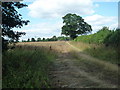
1
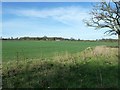
Wick Farm across fields
Taken from the Icknield Way Long Distance Path (LDP) as it runs next to Grim's Ditch to the south of Tring. Wick Farm itself is on the even more famous Ridgeway LDP, showing how close these two LDPs are at this point (they actually meet a few miles away near Aldbury in a confusion of red lozenges on the OS 1:50000 maps !).
Image: © Rob Farrow
Taken: 6 Apr 2011
0.01 miles
3
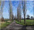
Rural Road near Wiggington
Road lined with Poplar trees
https://en.wikipedia.org/wiki/Wigginton,_Hertfordshire
Image: © James Emmans
Taken: 19 Jan 2016
0.09 miles
4
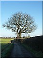
Large tree near Wick Farm
This large tree is on the southern side of the footpath (formerly part of the Ridgeway see Image]) as it approaches Wick Farm about halfway between Hastoe Cross and the village of Wigginton.
Image: © Rob Farrow
Taken: 28 Dec 2014
0.15 miles
5
Farm track to Wicks Farm
The Icknield Way is not signposted at all along this stretch. This track off the footpath leads to Wicks Farm. It is not the footpath.
Image: © Tom Presland
Taken: 11 Aug 2010
0.18 miles
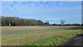
6
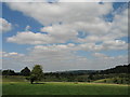
Tring Park
Tring Park originally formed part of the estate of the banker Lionel de Rothschild and his son Nathaniel (1st Baron Rothschild of Tring) who made sweeping changes to the mansion, to the estate farms and its other buildings, and who opened the Tring Zoological Museum as a gift to his son Walter - the Museum now forms part of 'The Natural History Museum' (and is well worth a visit). Walter Rothschild was responsible for introducing numerous exotic animals - including wallabies, cassowaries, quaggas and rheas - into the Park's extensive grassland. Today the Park, which is managed by the Woodland Trust, is home to much less exotic sheep and cattle. This view is towards is towards Pitstone Hill (skyline, centre).
Image: © Gerald Massey
Taken: 18 Aug 2009
0.18 miles
7
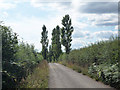
Poplar trees by road
These poplar trees on rising ground by the side of a private road can be seen from a considerable way away.
Image: © Tom Presland
Taken: 11 Aug 2010
0.24 miles