IMAGES TAKEN NEAR TO
Wigginton, TRING, HP23 6DP
Introduction
This page details the photographs taken nearby to HP23 6DP by members of the Geograph project.
The Geograph project started in 2005 with the aim of publishing, organising and preserving representative images for every square kilometre of Great Britain, Ireland and the Isle of Man.

There are currently over 7.5m images from over14,400 individuals and you can help contribute to the project by visiting https://www.geograph.org.uk
Image Map
Images are licensed for reuse under creativecommons.org/licenses/by-sa/2.0
Notes
- Clicking on the map will re-center to the selected point.
- The higher the marker number, the further away the image location is from the centre of the postcode.
Image Listing (11 Images Found)
Images are licensed for reuse under creativecommons.org/licenses/by-sa/2.0
Image
Details
Distance
3
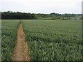
Chiltern Way
Chiltern Way cutting across field heading to Crawley's Lane by the A41
Image: © Shaun Ferguson
Taken: 22 Jun 2009
0.06 miles
4
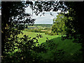
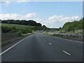
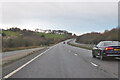
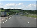
View down to Cow Roast
View down towards Cow Roast. The A41 bypass passes through the valley.
Image: © Tom Presland
Taken: 11 Aug 2010
0.07 miles
5
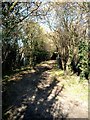
Lane to Hill Green Farm near Tinker's Lodge
This is the other end of the lane pictured in
http://www.geograph.org.uk/photo/106727
Image: © Rob Farrow
Taken: 2 Mar 2006
0.08 miles