IMAGES TAKEN NEAR TO
New Ground Road, TRING, HP23 5RQ

Introduction

This page details the photographs taken nearby to New Ground Road, HP23 5RQ by members of the Geograph project.

The Geograph project started in 2005 with the aim of publishing, organising and preserving representative images for every square kilometre of Great Britain, Ireland and the Isle of Man.

There are currently over 7.5m images from over14,400 individuals and you can help contribute to the project by visiting https://www.geograph.org.uk

Image Map


Images are licensed for reuse under creativecommons.org/licenses/by-sa/2.0
Notes
  • Clicking on the map will re-center to the selected point.
  • The higher the marker number, the further away the image location is from the centre of the postcode.

Image Listing (190 Images Found)

Images are licensed for reuse under creativecommons.org/licenses/by-sa/2.0
  • ...
Image
Details
Distance
1
The Valiant Trooper , Aldbury
The Valiant Trooper http://www.valianttrooper.co.uk/ was packed out when this picture was taken during the May Bank Holiday Celebrations.
Image: © Chris Reynolds Taken: 2 May 2016
0.06 miles
2
Aldbury : "The Valiant Trooper" public house
Grade II listed : description at this https://historicengland.org.uk/listing/the-list/list-entry/1347794.
Image: © Jim Osley Taken: 17 Jun 2021
0.06 miles
3
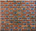
Wall: "The Valiant Trooper", Aldbury
Flemish bond with black headers: this arrangement is common in this area.
Image: © Dylan Moore Taken: 31 Jan 2013
0.07 miles
4
Valiant Trooper
Public House in Aldbury.
Image: © Wayland Smith Taken: 18 Apr 2021
0.07 miles
5
Aldbury, seen from the Gallops
See also: Image; Image; Image; Image; Image; Image
Image: © Gerald Massey Taken: 17 Nov 2009
0.07 miles
6
Aldbury - Malting Lane
A path descends from the hairpin at the top of Toms Hill to the southeast of Aldbury back into the village, rejoining the metalled road at the end of Malting Lane. This view is from the bottom of the path looking along Malting Lane towards the rest of Aldbury village.
Image: © Rob Farrow Taken: 13 Nov 2011
0.09 miles
7
House, Valiant Trooper Road, Aldbury
Image: © Gerald Massey Taken: 30 Oct 2009
0.16 miles
8
Chiltern Way
Chiltern Way nears Malting Lane on the edge of Aldbury before cutting right to follow the footpath to Berkhamsted Common.
Image: © Shaun Ferguson Taken: 22 Jun 2009
0.16 miles
9
Parish Barbecue in the garden of Aldbury Vicarage
A barbecue has been held in the vicarage garden every summer for a number of years, and there is a excellent view from the garden towards Tom's Hill.
Image: © Chris Reynolds Taken: 21 Jun 2009
0.16 miles
10
Aldbury Vicarage
The Aldbury Vicarage is a modern building conveniently situated across the road from the parish church.
Image: © Chris Reynolds Taken: 21 Jun 2009
0.17 miles
  • ...