IMAGES TAKEN NEAR TO
Grove Park, TRING, HP23 5JR
Introduction
This page details the photographs taken nearby to Grove Park, HP23 5JR by members of the Geograph project.
The Geograph project started in 2005 with the aim of publishing, organising and preserving representative images for every square kilometre of Great Britain, Ireland and the Isle of Man.

There are currently over 7.5m images from over14,400 individuals and you can help contribute to the project by visiting https://www.geograph.org.uk
Image Map
Images are licensed for reuse under creativecommons.org/licenses/by-sa/2.0
Notes
- Clicking on the map will re-center to the selected point.
- The higher the marker number, the further away the image location is from the centre of the postcode.
Image Listing (57 Images Found)
Images are licensed for reuse under creativecommons.org/licenses/by-sa/2.0
Image
Details
Distance
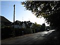
1
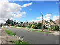
Grove Park, Tring
The name Tring is thought to come from Old English "Trehangr" meaning forested hillside.
Image: © Des Blenkinsopp
Taken: 23 Sep 2016
0.02 miles
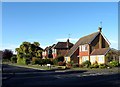
2
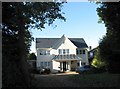
Grove Road, Tring
This house was recently - and tastefully - rebuilt. A huge improvement on its squat utilitarian predecessor.
Image: © Gerald Massey
Taken: 24 Oct 2009
0.05 miles
3

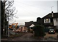
Demolition: No.100, Grove Road, Tring
See also Image
Image: © Gerald Massey
Taken: 8 Dec 2009
0.07 miles
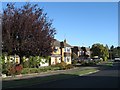
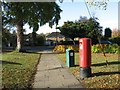
7
Junction of Grove Park and Grange Road, Tring
Image: © Gerald Massey
Taken: 23 Oct 2009
0.08 miles
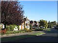
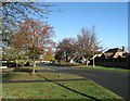
8
Junction of Grove Road and Grove Park, Tring
Image: © Gerald Massey
Taken: 23 Oct 2009
0.10 miles
10
Demolition: No.100 Grove Road, Tring
See also Image
Image: © Gerald Massey
Taken: 8 Dec 2009
0.11 miles