IMAGES TAKEN NEAR TO
Grove Park, TRING, HP23 5JL
Introduction
This page details the photographs taken nearby to Grove Park, HP23 5JL by members of the Geograph project.
The Geograph project started in 2005 with the aim of publishing, organising and preserving representative images for every square kilometre of Great Britain, Ireland and the Isle of Man.

There are currently over 7.5m images from over14,400 individuals and you can help contribute to the project by visiting https://www.geograph.org.uk
Image Map (Loading...)


Getting Data...Please wait
Leaflet Map data © OpenStreetMap
Images are licensed for reuse under creativecommons.org/licenses/by-sa/2.0
Notes
- Clicking on the map will re-center to the selected point.
- The higher the marker number, the further away the image location is from the centre of the postcode.
Image Listing (77 Images Found)
Images are licensed for reuse under creativecommons.org/licenses/by-sa/2.0
Image
Details
Distance
1
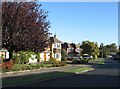
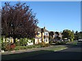
Junction of Grange Road and Grove Park, Tring
This house has been extensively extended and for that reason looks very out-of-place in the neighbourhood.
Image: © Gerald Massey
Taken: 23 Oct 2009
0.02 miles
4
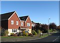
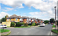
Junction of Grove Park and Grange Road, Tring
Image: © Gerald Massey
Taken: 23 Oct 2009
0.06 miles
8
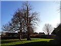
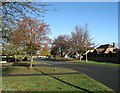
Tring - Undeveloped land on Chiltern Way
There is a substantial plot of land that remains undeveloped between the houses on the south-eastern side of Chiltern Way. The area dog-legs round to the right and expands to an open grassy area. I am not sure why this little area was not developed - perhaps it was designated as "Public Open Space".
Image: © Rob Farrow
Taken: 28 Feb 2021
0.08 miles
9
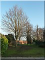
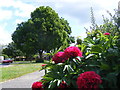
Undeveloped plot, Chiltern Way
This angled plot of land on Chiltern Way remains undeveloped amidst all the houses that were built here in the 1970s. Presumably intentionally left as Public Open Space as part of the planning permission. The tall red-brick wall clearly predates surrounding development and must have belonged to a grand house long since demolished I would think.
Image: © Rob Farrow
Taken: 19 Feb 2013
0.08 miles