IMAGES TAKEN NEAR TO
High Street, TRING, HP23 5AL
Introduction
This page details the photographs taken nearby to High Street, HP23 5AL by members of the Geograph project.
The Geograph project started in 2005 with the aim of publishing, organising and preserving representative images for every square kilometre of Great Britain, Ireland and the Isle of Man.

There are currently over 7.5m images from over14,400 individuals and you can help contribute to the project by visiting https://www.geograph.org.uk
Image Map
Images are licensed for reuse under creativecommons.org/licenses/by-sa/2.0
Notes
- Clicking on the map will re-center to the selected point.
- The higher the marker number, the further away the image location is from the centre of the postcode.
Image Listing (708 Images Found)
Images are licensed for reuse under creativecommons.org/licenses/by-sa/2.0
Image
Details
Distance
1
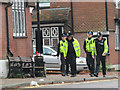
The Remembrance Day Procession at Tring (2)
The Police pass the town centre bus stop on their way to stop the traffic while the procession takes place.
Previous Image
Next Image
Image: © Chris Reynolds
Taken: 8 Nov 2015
0.01 miles
2
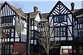
The former Rose and Crown Inn, Tring
This prominent building dates from 1905 when it replaced a coaching inn on the site. The architect was William Huckvale who designed many of the buildings on Lord Rothschild's estate; here the aim was to ensure that sufficient rooms were available for the many guests who could not be accommodated in the Rothschild mansion in Tring Park. Sadly, despite its location opposite the parish church, the inn was closed in 2013 and has been converted into flats. See Image for a view before closure.
Image: © Stephen McKay
Taken: 22 Apr 2021
0.01 miles
3
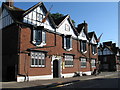
The Counting House, Tring
The 'Counting House', a Grade II listed building, is one of a number of examples in Tring of the work of architect William Huckvale (1848-1936), although in this case an adaptation of earlier buildings rather than an entirely new construction. Formerly the Rothschild Estate Office, it was used for the day to day running of the estate. The building is now owned by Dacorum council who let it to commercial tenants.
Image: © Gerald Massey
Taken: 3 Jul 2009
0.01 miles
4
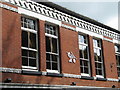
Former "Unity Hall", Tring
This building in Tring's Lower High Street was built in 1880 by the Co-operative Society and there was a Co-op store on the site until the 1980s. At some point the upstairs (shown here), which housed "Unity Hall", became Tring's first cinema, "The Gem Picture Palace" showing pictures that were "very fine and free from vulgarity." The Gem moved to purpose-built premises in Western Road, Tring, 1916.
Image: © Gerald Massey
Taken: 7 Jul 2009
0.01 miles
8
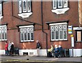
Waiting for the Bus, High Street, Tring
The building in the background - The Counting House - is by architect William Huckvale whose work is well represented in the Town (pity about the boarded-up window).
Image: © Gerald Massey
Taken: 20 Nov 2009
0.01 miles
10
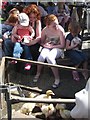
Tring Spring Fayre in Church Square 2009: Children with baby animals
Image: © Chris Reynolds
Taken: 2 May 2009
0.01 miles