IMAGES TAKEN NEAR TO
Long Marston, TRING, HP23 4QX
Introduction
This page details the photographs taken nearby to HP23 4QX by members of the Geograph project.
The Geograph project started in 2005 with the aim of publishing, organising and preserving representative images for every square kilometre of Great Britain, Ireland and the Isle of Man.

There are currently over 7.5m images from over14,400 individuals and you can help contribute to the project by visiting https://www.geograph.org.uk
Image Map (Loading...)


Getting Data...Please wait
Leaflet Map data © OpenStreetMap
Images are licensed for reuse under creativecommons.org/licenses/by-sa/2.0
Notes
- Clicking on the map will re-center to the selected point.
- The higher the marker number, the further away the image location is from the centre of the postcode.
Image Listing (17 Images Found)
Images are licensed for reuse under creativecommons.org/licenses/by-sa/2.0
Image
Details
Distance
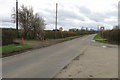
5
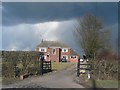
Long Leys Farm
View to the North East from Station Road, which leads from Long Marston to Wingrave. The dark clouds turned into snow.
Image: © Chris Cole
Taken: 1 Mar 2006
0.08 miles
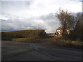
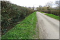
8
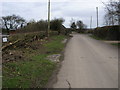
Potash Lane
Potash Lane nearing junction with Station Road
Image: © Shaun Ferguson
Taken: 25 Feb 2011
0.10 miles
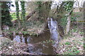
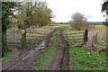
9
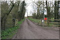
Footpath towards The New Barn and The Aylesbury Ring
Image: © Philip Jeffrey
Taken: 14 Mar 2020
0.11 miles