IMAGES TAKEN NEAR TO
Watery Lane, TRING, HP23 4PH
Introduction
This page details the photographs taken nearby to Watery Lane, HP23 4PH by members of the Geograph project.
The Geograph project started in 2005 with the aim of publishing, organising and preserving representative images for every square kilometre of Great Britain, Ireland and the Isle of Man.

There are currently over 7.5m images from over14,400 individuals and you can help contribute to the project by visiting https://www.geograph.org.uk
Image Map
Images are licensed for reuse under creativecommons.org/licenses/by-sa/2.0
Notes
- Clicking on the map will re-center to the selected point.
- The higher the marker number, the further away the image location is from the centre of the postcode.
Image Listing (60 Images Found)
Images are licensed for reuse under creativecommons.org/licenses/by-sa/2.0
Image
Details
Distance
2
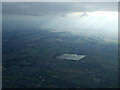
The Tring reservoirs from the air
Seen just before entering the cloud blanket, Wilstone is the square reservoir in the centre of the photo. Startopsend reservoir, Marsworth Reservoir and Tringford reservoir can be seen towards the lower left corner.
All four reservoirs are owned by British Waterways and provide a water supply to the Grand Union Canal which can be seen diagonally crossing the lower right corner of the photo.
The reservoirs are a designated "Biological Site of Special Scientific Interest". They are important habitats for wildfowl and other wetland birds. This http://www.tringreservoirs.org.uk/p/history-of-reservoirs.html provide more information about the wildlife to be found there as well as a section on the history of the reservoirs.
Image: © Thomas Nugent
Taken: 29 Mar 2013
0.06 miles
3
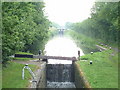
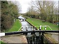
Grand Union Canal
Locks on the Aylesbury Arm of the Grand Union Canal, just north of Wilstone.
Image: © David Griffiths
Taken: 30 Jun 2005
0.06 miles
4
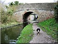
Aylesbury Arm: Wilstone Bridge (No 3)
Image: © Chris Reynolds
Taken: 14 Mar 2009
0.06 miles
5
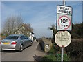
Aylesbury Arm ? Hump-backed Bridge (No.3) at Wilstone
This bridge was built 200 years ago and was not designed for modern traffic. It is very narrow, with a distinct hump and its load-bearing capacity is limited.
Image
Image: © Chris Reynolds
Taken: 18 Mar 2009
0.07 miles
6
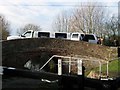
This Stretch Limo has got the Hump
This picture shows the lower gate of Lock No 8 and Bridge No 3 (Image) of the Aylesbury Arm at Wilstone. A stretch limo came this way, probably because Bridge No 2 (Image) was still closed, and grounded on the hump! All the “honoured passengers” got out and this allowed the limo to continue with only comparatively minor scraping noises.
Image
Image: © Chris Reynolds
Taken: 5 Dec 2009
0.07 miles
7
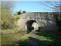
Bridge 3, Grand Junction Canal - Aylesbury Arm - Wilstone Bridge
Image: © Mr Biz
Taken: 27 Mar 2012
0.07 miles
8
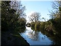
Aylesbury Arm - view westward from Wilstone Bridge
Wilstone Bridge is just to the north of the village of Wilstone where Tring Road crosses the Aylesbury Arm of the Grand Union Canal - sometimes simply referred to as the "Aylesbury Canal". This view is westwards looking at the long pound between Locks 8 and 9.
Image: © Rob Farrow
Taken: 19 Jan 2014
0.07 miles
9
Aylesbury Arm: Wilstone Lock (No 8)
Image: © Chris Reynolds
Taken: 14 Mar 2009
0.07 miles
10
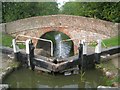
Grand Union Canal: Aylesbury Arm: Bridge No 3
Bridge No 3 is Wilstone Bridge and takes Tring Road over the canal. It dates from around 1811 to 1814 when the canal was built. With Lock No 8, from which this photograph was taken, the pair jointly form a Grade II Listed structure.
Image: © Nigel Cox
Taken: 4 Sep 2014
0.08 miles