IMAGES TAKEN NEAR TO
Glebe Meadow, HP23 4GA

Introduction

This page details the photographs taken nearby to Glebe Meadow, HP23 4GA by members of the Geograph project.

The Geograph project started in 2005 with the aim of publishing, organising and preserving representative images for every square kilometre of Great Britain, Ireland and the Isle of Man.

There are currently over 7.5m images from over14,400 individuals and you can help contribute to the project by visiting https://www.geograph.org.uk

Image Map


Images are licensed for reuse under creativecommons.org/licenses/by-sa/2.0
Notes
  • Clicking on the map will re-center to the selected point.
  • The higher the marker number, the further away the image location is from the centre of the postcode.

Image Listing (41 Images Found)

Images are licensed for reuse under creativecommons.org/licenses/by-sa/2.0
  • ...
Image
Details
Distance
1
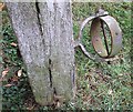
Flagpole fixing
A close-up of the lower fixing bracket of the old flagpole base seen in Image]
Image: © Rob Farrow Taken: 7 Jul 2010
0.04 miles
2
Old flagpole stand
I wondered for a while if this was some ancient form of punishment akin to the stocks, but realised after a while that it is the remains of the base of a flagpole. The rings top and bottom would have secured the tall cylindrical pole against this sturdy wooden base. For a close-up of one of the rings see Image] It is situated in the churchyard of Image] a few metres to the west of its west end.
Image: © Rob Farrow Taken: 7 Jul 2010
0.04 miles
3
All Saints Church, Long Marston ? Charity Board
An Account of ye several Sums of Money left to ye Church-Warden of ye Hamlet of Long Marston in ye Parish of Tring NB the Yearly Interest of which Money to be Annually Distributed to ye Poor of the said Hamlet in the Month of May. 1604 Jno Wing £6/13/4 1604 Jno Cock £3/0/0 1706 W Puttnam £4/6/8 1767 Micl Nash one Acre of Arable Land in Brook furlong next the Headland Value Annually 10/6 W Nash Church-Warden: 1814
Image: © Chris Reynolds Taken: 9 Sep 2006
0.05 miles
4
All Saints, Long Marston
This towerless, spireless, little flint-dashed Victorian church serves the village of Long Marston, and replaced the venerable chapel of ease (also All Saints), the tower of which survives (see Image] et seq.) C of E website http://www.achurchnearyou.com/long-marston-all-saints/
Image: © Rob Farrow Taken: 7 Jul 2010
0.05 miles
5
Pylon on Station Road, Long Marston
Image: © David Howard Taken: 22 Aug 2021
0.06 miles
6
All Saints Church, Long Marston
In 1881 the old church was deemed unsafe and it was decided to demolish it (apart from the tower http://www.geograph.org.uk/photo/181239 ) and to build this church on drier land on the north side of the village. The land was given by Lord Rothschild, Lord of the Manor, and the cost was £4,000.
Image: © Chris Reynolds Taken: 14 Mar 2009
0.06 miles
7
All Saints Church, Long Marston ? West End
While this church was consecrated in 1883 it was not finished until 1888 due to lack of funds, and plans to build a church tower at the west end were abandoned.
Image: © Chris Reynolds Taken: 14 Mar 2009
0.07 miles
8
All Saints Church, Long Marston ? East End
As the old church was being demolished parts were renewed, including the north aisle, fifteenth century piscine and two fourteenth century windows.
Image: © Chris Reynolds Taken: 14 Mar 2009
0.07 miles
9
All Saints' church
Image: © Philip Jeffrey Taken: 14 Mar 2020
0.07 miles
10
All Saints Church, Long Marston
Image: © David Howard Taken: 11 Feb 2018
0.07 miles
  • ...