1
The Queens Head, Long Marston
Image: © Mr Biz
Taken: 25 Feb 2012
0.02 miles
2
Tring Road, Long Marston
Image: © David Howard
Taken: 22 Aug 2021
0.02 miles
3
The Queens Head, Long Marston
At the crossroads in the village. To the right the building has a sign 'Ye Olde Queens Head Stables'.
Image: © Robin Webster
Taken: 5 Jun 2014
0.02 miles
4
The Queens Head pub and the former White Hart Inn, Long Marston
The Queens Head is a C16 building, heightened in C17. The building on the right was built in C17 and used to be the White Hart Inn but it has been closed for many years.
Image: © Bikeboy
Taken: 21 Aug 2014
0.02 miles
5
Back of the Queen's Head pub, Long Marston
This has been converted from a barn built in C16.
Image: © Bikeboy
Taken: 21 Aug 2014
0.03 miles
6
Stripy poles on Cheddington Lane, Long Marston
These are on both sides of the roads to protect the buildings from traffic. They clearly work well as none have been damaged.
Image: © David Howard
Taken: 22 Aug 2021
0.03 miles
7
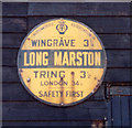
Old circular AA Sign on Cheddington Lane, Long Marston
Old AA Sign set on the southwest end of a converted barn behind the Queens Head PH on Cheddington Lane, Long Marston, 3½ miles northwest of Tring. Tring Rural parish.
This is the Circular, village name on black band, no Motor Union symbol or name type, dating from 1923, showing distances Wingrave 3¼ Tring 3½ London 34½.
There were five series of AA signs, mostly dating from 1923 and made by Francis & Co / Franco in Deptford, London. The village name and distance to London were displayed.
Milestone Society National ID: HE-LONGM
Image: © Milestone Society
Taken: Unknown
0.03 miles
8
Cheddington Lane, Long Marston
Image: © David Howard
Taken: 22 Aug 2021
0.03 miles
9
Street Corner in Long Marston
At the cross roads in the middle of the village. Station Road on the left, Cheddington Lane on the right.
I wondered about this, seeing as Cheddington Lane goes to a station and Station Road doesn't, but the map shows a dismantled railway some distance north west of the village, which is where the station was.
Image Image
Image: © Des Blenkinsopp
Taken: 29 Oct 2019
0.04 miles
10
Astrope Lane, Long Marston
Towards the village centre.
Image: © Robin Webster
Taken: 5 Jun 2014
0.05 miles


