1
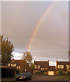
Rainbow over Christchurch Road, Tring
A sharp shower and a setting sun means that the rainbow points straight down into the ground - but as always - the pot of gold must have been at the other end of the rainbow.
Image: © Chris Reynolds
Taken: 11 Oct 2014
0.03 miles
2
A Double Rainbow over Mill View Road, Tring
This was taken a few minutes after a very short but sharp shower had passed by.
The rainbow reaches down to the ground almost vertically - indicating that the picture was taken just before sunset.
Image: © Chris Reynolds
Taken: 11 Oct 2014
0.04 miles
3
Millview Rd, Tring
Image: © John Lord
Taken: 6 Mar 2014
0.05 miles
4
Christchurch Road Shops, Tring, in 2009
While the building has remained the same over the years the shop fronts have changed. The nearest shop had originally been a local sub-post office and newsagents. By the time this picture was taken it was only a newsagent, although the cylinder post box remained. The further shop had been used by an interior decorator but, as the picture shows, became a Pilates Studio.
By 2013 (
Image) The nearest shop had become a Londis store - while still selling newspapers - and the other had become a Ladies hairdressers.
Image: © Chris Reynolds
Taken: 21 Apr 2009
0.06 miles
5
The Christchurch Road Shops - Tring
These two units were built circa 1960s to service the housing estates on the ridge to the north of the town of Tring. The first shop was originally a newsagent and a post office - and the cylinder post box is still there. The post office was closed down early in the 21st century and became little more than a distribution office for the newspaper round. It closed at the end of May 2013 and after a major refit opened as a Londis store a couple of days before this picture was taken.
The shop next door has also changed over the years - and recently opened as a Ladies Hairdresser
Image: © Chris Reynolds
Taken: 9 Jun 2013
0.06 miles
6
Shops, Christchurch Rd, Tring
Image: © John Lord
Taken: 6 Mar 2014
0.06 miles
7
Osmington Place, Tring
Osmington place is one of the late 20th century housing developments off Christchurch Road, in the grounds of the former Osmington Prep School.
Image: © Chris Reynolds
Taken: 9 Jun 2013
0.10 miles
8
The Sports Pavilion, Goldfield, Tring
This sad looking building has been a regular target for vandals ever since it was built - which is a great shame.
Image: © Chris Reynolds
Taken: 9 Jun 2013
0.16 miles
9
The Football Field, Goldfield, Tring
Goldfield is a large open area between Miswell lane (the houses in the distance) and Christchurch Road. This picture of the football field is taken from the entrance to a footpath which runs alongside Osmington Place.
Image: © Chris Reynolds
Taken: 9 Jun 2013
0.17 miles
10
A Dangerous Fallen Tree on Goldfield
The day before this was taken the Storm "Doris" had passed over the area bringing down many trees. A number, like this one, were old and covered with ivy, and were particularly vulnerable.
The fallen tree forms a bridge over an informal footpath, much used by dog walkers and children, which runs between a football field and a park area with swings. It is also not far from the footpath from Tring to Drayton Beachamp. Not much appears to be stopping the tree falling further as it is only supported six foot above the ground because its top branches had tangled with the branches of another, still standing, tree.
I have notified the Council and it will be interesting to see how quickly it is made safe.
Image: © Chris Reynolds
Taken: 24 Feb 2017
0.18 miles


