IMAGES TAKEN NEAR TO
London Road, AYLESBURY, HP22 6PG
Introduction
This page details the photographs taken nearby to London Road, HP22 6PG by members of the Geograph project.
The Geograph project started in 2005 with the aim of publishing, organising and preserving representative images for every square kilometre of Great Britain, Ireland and the Isle of Man.

There are currently over 7.5m images from over14,400 individuals and you can help contribute to the project by visiting https://www.geograph.org.uk
Image Map (4 Images)


Getting Data...Please wait
Leaflet Map data © OpenStreetMap
Images are licensed for reuse under creativecommons.org/licenses/by-sa/2.0
Notes
- Clicking on the map will re-center to the selected point.
- The higher the marker number, the further away the image location is from the centre of the postcode.
Image Listing (4 Images Found)
Images are licensed for reuse under creativecommons.org/licenses/by-sa/2.0
Image
Details
Distance
1
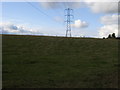
Electricity Pylon
Electricity Pylon off the lane to Smalldene Farm
Image: © Shaun Ferguson
Taken: 3 Oct 2008
0.15 miles
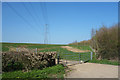
3

Fields at Grove Farm, Wendover
Looking south from the footpath adjacent to Wendover by-pass. The fields are on the route of the proposed new high speed railway line from London to Birmingham.
Image: © Simon Mortimer
Taken: 6 Jul 2010
0.22 miles