IMAGES TAKEN NEAR TO
Bacombe Lane, AYLESBURY, HP22 6EQ
Introduction
This page details the photographs taken nearby to Bacombe Lane, HP22 6EQ by members of the Geograph project.
The Geograph project started in 2005 with the aim of publishing, organising and preserving representative images for every square kilometre of Great Britain, Ireland and the Isle of Man.

There are currently over 7.5m images from over14,400 individuals and you can help contribute to the project by visiting https://www.geograph.org.uk
Image Map
Images are licensed for reuse under creativecommons.org/licenses/by-sa/2.0
Notes
- Clicking on the map will re-center to the selected point.
- The higher the marker number, the further away the image location is from the centre of the postcode.
Image Listing (12 Images Found)
Images are licensed for reuse under creativecommons.org/licenses/by-sa/2.0
Image
Details
Distance
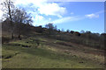
2
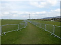
Path with temporary fencing near Wendover
Crowd control barriers used as fencing here to stop walkers wandering off the path.
Image: © Jeremy Bolwell
Taken: 14 Apr 2019
0.17 miles
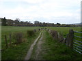
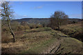
6
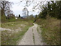
Path between Coombe Hill and Wendover
Near Wendover, ahead.
Image: © Jeremy Bolwell
Taken: 14 Apr 2019
0.20 miles
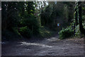
7
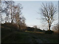
Old chalkpit by the Ridgeway near Wendover
Image: © Robert Eva
Taken: 15 Feb 2018
0.20 miles
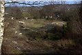
9
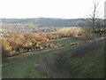
View back down Bacombe Hill
Wendover is the town in the distance.
Image: © Peter S
Taken: 20 Dec 2011
0.21 miles