IMAGES TAKEN NEAR TO
Aesop Road, AYLESBURY, HP22 5XX
Introduction
This page details the photographs taken nearby to Aesop Road, HP22 5XX by members of the Geograph project.
The Geograph project started in 2005 with the aim of publishing, organising and preserving representative images for every square kilometre of Great Britain, Ireland and the Isle of Man.

There are currently over 7.5m images from over14,400 individuals and you can help contribute to the project by visiting https://www.geograph.org.uk
Image Map
Images are licensed for reuse under creativecommons.org/licenses/by-sa/2.0
Notes
- Clicking on the map will re-center to the selected point.
- The higher the marker number, the further away the image location is from the centre of the postcode.
Image Listing (13 Images Found)
Images are licensed for reuse under creativecommons.org/licenses/by-sa/2.0
Image
Details
Distance

3
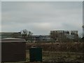
Arla grows - view from College Road
This is the view of the rapidly burgeoning Arla dairy taken from College Road just to the north of the recycling centre / dump. See shared description below.
See also Image] and Image]
Image: © Rob Farrow
Taken: 6 Jan 2013
0.18 miles
4
Work starts on New Recycling Centre near Aston Clinton
Image: © Chris Reynolds
Taken: 23 Apr 2009
0.19 miles
5
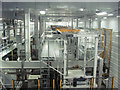
The Bottle Making Plant in the Arla Factory at Aston Clinton
All the plastic milk bottles are made on site - with the bottles being filled with milk in the adjacent room.
Obviously cleanliness is all important when processing milk on this scale - so this picture was taken from a high level corridor which runs between the various vast working areas in the factory.
See a view of the area taken about two years earlier Image
Image: © Chris Reynolds
Taken: 28 Oct 2014
0.19 miles
6
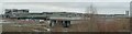
Arla panorama (under construction)
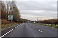
The enormous monstrosity that is the new Arla milk processing plant to the north of Aston Clinton has been growing dramatically with every week over the last few months. This is the view of it from the bridge which carries the dead-end road from Buckland village to Monks Court over the A41 dual carriageway.
I suggest using the "More sizes" option above the image to see a far more detailed version of this photo if you want to see any detail.
See shared description below.
Image: © Rob Farrow
Taken: 6 Jan 2013
0.19 miles
7
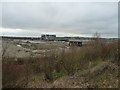
Arla under construction
The enormous Arla dairy under construction to the north of Aston Clinton adjacent to the A41. Taken from the same bridge as Image]
See shared description below.
Image: © Rob Farrow
Taken: 6 Jan 2013
0.19 miles
8
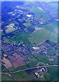
RAF Halton from the air
A pair of grass runways forming an X can be seen in the centre of the photo. The A41 Aston Clinton bypass road runs across the bottom of the photo. Click on this http://en.wikipedia.org/wiki/RAF_Halton to go to the wikipedia article about the base. Viewed from a Heathrow bound flight from Glasgow.
Image: © Thomas Nugent
Taken: 10 Apr 2011
0.21 miles
9
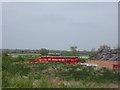
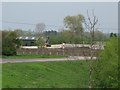
Piled Skips on industrial site near Aston Clinton
See also Image
Image: © Chris Reynolds
Taken: 23 Apr 2009
0.22 miles
10
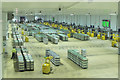
Bottled Milk ready for delivery to the Shops in the Arla Factory
Behind the wall on the right plastic bottles are filled with milk and packed, the bottles being made in the next room along Image
When a batch is ready it is collected by a robot (seen queuing to collect its load) and these then take the crates of bottles and place them in the appropriate area for later loading into lorries to deliver the milk to the shops. Virtually everything is computer controlled, but a small number of humans supervise the operation in case there are any difficulties.
Image: © Chris Reynolds
Taken: 28 Oct 2014
0.23 miles