IMAGES TAKEN NEAR TO
Field Rose, AYLESBURY, HP22 5XG
Introduction
This page details the photographs taken nearby to Field Rose, HP22 5XG by members of the Geograph project.
The Geograph project started in 2005 with the aim of publishing, organising and preserving representative images for every square kilometre of Great Britain, Ireland and the Isle of Man.

There are currently over 7.5m images from over14,400 individuals and you can help contribute to the project by visiting https://www.geograph.org.uk
Image Map (Loading...)


Getting Data...Please wait
Leaflet Map data © OpenStreetMap
Images are licensed for reuse under creativecommons.org/licenses/by-sa/2.0
Notes
- Clicking on the map will re-center to the selected point.
- The higher the marker number, the further away the image location is from the centre of the postcode.
Image Listing (6 Images Found)
Images are licensed for reuse under creativecommons.org/licenses/by-sa/2.0
Image
Details
Distance
2
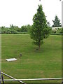
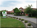
Hotel grounds, Aylesbury
At the back of the Holiday Inn.
Image: © Gareth James
Taken: 6 Jun 2010
0.19 miles
3
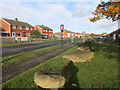
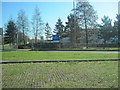
Rocks by the Bus Stop
Along Welbeck Avenue. The rocks are at the entrance to a small park and I guess are there to stop parking on the grass.
A feature around Aylesbury are these very prominent bus stops, halfway to pub signs.
Image: © Des Blenkinsopp
Taken: 18 Nov 2016
0.21 miles
6
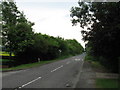
Holiday Inn entrance from A41
At Weston Turville
Image: © John Firth
Taken: 19 Mar 2012
0.23 miles