IMAGES TAKEN NEAR TO
Coombe Close, AYLESBURY, HP22 5UD
Introduction
This page details the photographs taken nearby to Coombe Close, HP22 5UD by members of the Geograph project.
The Geograph project started in 2005 with the aim of publishing, organising and preserving representative images for every square kilometre of Great Britain, Ireland and the Isle of Man.

There are currently over 7.5m images from over14,400 individuals and you can help contribute to the project by visiting https://www.geograph.org.uk
Image Map
Images are licensed for reuse under creativecommons.org/licenses/by-sa/2.0
Notes
- Clicking on the map will re-center to the selected point.
- The higher the marker number, the further away the image location is from the centre of the postcode.
Image Listing (14 Images Found)
Images are licensed for reuse under creativecommons.org/licenses/by-sa/2.0
Image
Details
Distance
1
Stoke Mandeville Station
Originally on the Metropolitan Line it is now on the national rail system.
Image: © David Howard
Taken: 10 Oct 2021
0.03 miles
2
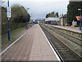
Stoke Mandeville railway station
Opened in 1892 by the Metropolitan Railway on the line from London Baker Street to Aylesbury. View north west towards Aylesbury.
Image: © Nigel Thompson
Taken: 16 Mar 2013
0.04 miles
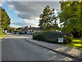
4
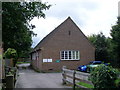
Telephone Exchange, Stoke Mandeville
Situated in Station Road, near Ligo Avenue, this TE has the code SMSMV. It provides telephone and broadband services to 2,166 residential and 112 non-residential premises in Stoke Mandeville, plus Kimblewick, Little Kimble, Marsh, Terrick and Weston Turville nearby. It has (01296) 61xxxx numbers, the (01296) referring to the Aylesbury group of fourteen TEs, and its postcode is HP22 5UA.
Image: © David Hillas
Taken: 29 Jul 2008
0.06 miles
5
Railway station, Stoke Mandeville
The picture shows part of the long wheelchair ramp down to the platform. The station opened in 1892 and now lies on the London Marylebone-Aylesbury line.
Image: © Bikeboy
Taken: 2 Jan 2015
0.08 miles
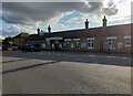
6
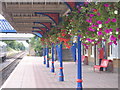
Stoke Mandeville Station
A beautifully tended platform in August 2005
Image: © Pip Rolls
Taken: 23 Aug 2005
0.08 miles
7
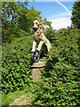
Lion and Unicycle
Sculpture in the garden at Stoke Mandeville station, recalling the early British Railways emblems involving a heraldic lion and a railway wheel. The first version, in use from 1948 to 1956 depicted the lion astride a wheel and was commonly known as the 'Lion and Unicycle' or 'Ferret and Dartboard'. From 1956 a revised version showed the lion grasping the wheel on a crown. There are several other sculptures in the garden.
Image: © Martin Addison
Taken: 4 Jun 2006
0.08 miles
8
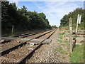
Towards Stoke Mandeville Station
The line to Aylesbury, from a footpath crossing.
Image: © Des Blenkinsopp
Taken: 13 Sep 2016
0.15 miles
9
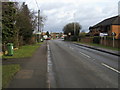
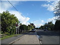
Station Road
Station Road (A4010) nearing the Wendover Road (A413) roundabout
Image: © Shaun Ferguson
Taken: 23 Jan 2009
0.21 miles