IMAGES TAKEN NEAR TO
Brook End, AYLESBURY, HP22 5RF
Introduction
This page details the photographs taken nearby to Brook End, HP22 5RF by members of the Geograph project.
The Geograph project started in 2005 with the aim of publishing, organising and preserving representative images for every square kilometre of Great Britain, Ireland and the Isle of Man.

There are currently over 7.5m images from over14,400 individuals and you can help contribute to the project by visiting https://www.geograph.org.uk
Image Map (Loading...)


Getting Data...Please wait
Leaflet Map data © OpenStreetMap
Images are licensed for reuse under creativecommons.org/licenses/by-sa/2.0
Notes
- Clicking on the map will re-center to the selected point.
- The higher the marker number, the further away the image location is from the centre of the postcode.
Image Listing (12 Images Found)
Images are licensed for reuse under creativecommons.org/licenses/by-sa/2.0
Image
Details
Distance
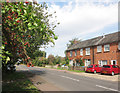
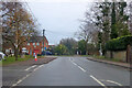
2
Brook End, Weston Turville
Leaving the village towards Aston Clinton.
Image: © Robin Webster
Taken: 5 Dec 2021
0.15 miles
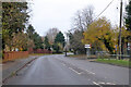
3
New Road, Western Turville
From Brook End
Image: © David Howard
Taken: 18 Dec 2022
0.15 miles
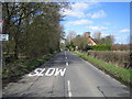
4
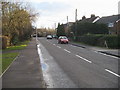
New Road
New Road nearing junction with Brook End
Image: © Shaun Ferguson
Taken: 23 Jan 2009
0.15 miles
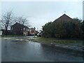
8
Weston Turville: Bye Green
Looking along an unnamed lane as it approaches Bye Green and the junction with the B4544 road to Aston Clinton, formerly The Lower Icknield Way.
Image: © Nigel Cox
Taken: 8 Apr 2006
0.19 miles
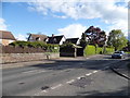
9
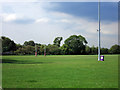
Ostler's Field, Brook End
Part of Aylesbury Rugby Club's ground.
Image: © Des Blenkinsopp
Taken: 13 Sep 2016
0.19 miles
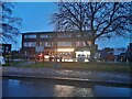
10
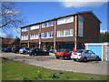
Weston Turville: Middle Field
The community shops and Post Office in Weston Turville, in Middle Field next to the B4544 Main Street.
Image: © Nigel Cox
Taken: 8 Apr 2006
0.21 miles