IMAGES TAKEN NEAR TO
Chestnut Close, AYLESBURY, HP22 5QR
Introduction
This page details the photographs taken nearby to Chestnut Close, HP22 5QR by members of the Geograph project.
The Geograph project started in 2005 with the aim of publishing, organising and preserving representative images for every square kilometre of Great Britain, Ireland and the Isle of Man.

There are currently over 7.5m images from over14,400 individuals and you can help contribute to the project by visiting https://www.geograph.org.uk
Image Map
Images are licensed for reuse under creativecommons.org/licenses/by-sa/2.0
Notes
- Clicking on the map will re-center to the selected point.
- The higher the marker number, the further away the image location is from the centre of the postcode.
Image Listing (53 Images Found)
Images are licensed for reuse under creativecommons.org/licenses/by-sa/2.0
Image
Details
Distance
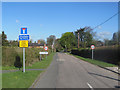
3
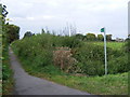
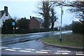
Footpath between Aston Clinton and Buckland
View of Buckland church in the distance (to the right).
Image: © David Sands
Taken: 29 Sep 2007
0.11 miles
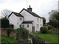
4
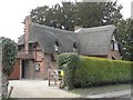
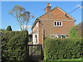
Yew Tree Cottage, Buckland
One of a number of thatched buildings in this attractive village
Image: © Chris Cole
Taken: 12 Mar 2006
0.14 miles
7
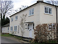
The Old Plough, Peggs Lane, Buckland
Image: © Chris Reynolds
Taken: 12 Mar 2009
0.17 miles
10
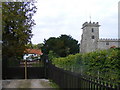
Church Leys, Buckland
Photograph of this old cottage taken from the churchyard
Image: © Chris Reynolds
Taken: 12 Mar 2009
0.18 miles