IMAGES TAKEN NEAR TO
Rowborough Road, AYLESBURY, HP22 5PL
Introduction
This page details the photographs taken nearby to Rowborough Road, HP22 5PL by members of the Geograph project.
The Geograph project started in 2005 with the aim of publishing, organising and preserving representative images for every square kilometre of Great Britain, Ireland and the Isle of Man.

There are currently over 7.5m images from over14,400 individuals and you can help contribute to the project by visiting https://www.geograph.org.uk
Image Map
Images are licensed for reuse under creativecommons.org/licenses/by-sa/2.0
Notes
- Clicking on the map will re-center to the selected point.
- The higher the marker number, the further away the image location is from the centre of the postcode.
Image Listing (6 Images Found)
Images are licensed for reuse under creativecommons.org/licenses/by-sa/2.0
Image
Details
Distance
1
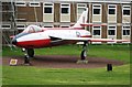
Jet Fighter on display at RAF Halton
This is on permanent display – effectively an advert for the RAF - and can be seen by people driving along the road to Wendover.
Image: © Chris Reynolds
Taken: 2 Apr 2009
0.13 miles
2
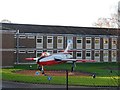
Gate guardian, RAF Halton
These planes put outside RAF bases are apparently known as "Gate Guardians". This one is Hawker Hunter and has been here since 1986. This one was built in Coventry and delivered to the RAF in 1956.
Image: © Bikeboy
Taken: 2 Jan 2015
0.13 miles
3
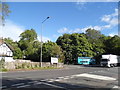
Chestnut Avenue at the entrance to RAF Halton
Image: © David Howard
Taken: 19 May 2015
0.15 miles
4
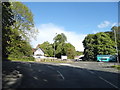
Chestnut Avenue at the junction of Upper Icknield Way
Looking towards the entrance to Halton RAF Camp
Image: © David Howard
Taken: 19 May 2015
0.17 miles
5
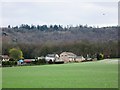
Wendover Heights, Halton
The buildings lie along the road from Tring to Wendover. The biggest building is Wendover Heights – a veterinary surgery – and other building are a Chinese take-away and a garage.
Image: © Chris Reynolds
Taken: 1 Apr 2009
0.20 miles
6
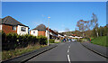
Wood Lane, Wendover
A residential street at the bottom of the Chiltern escarpment. The housing goes up the slope in steps.
Image: © Des Blenkinsopp
Taken: 13 Apr 2023
0.24 miles