IMAGES TAKEN NEAR TO
High Moors, AYLESBURY, HP22 5NY
Introduction
This page details the photographs taken nearby to High Moors, HP22 5NY by members of the Geograph project.
The Geograph project started in 2005 with the aim of publishing, organising and preserving representative images for every square kilometre of Great Britain, Ireland and the Isle of Man.

There are currently over 7.5m images from over14,400 individuals and you can help contribute to the project by visiting https://www.geograph.org.uk
Image Map
Images are licensed for reuse under creativecommons.org/licenses/by-sa/2.0
Notes
- Clicking on the map will re-center to the selected point.
- The higher the marker number, the further away the image location is from the centre of the postcode.
Image Listing (51 Images Found)
Images are licensed for reuse under creativecommons.org/licenses/by-sa/2.0
Image
Details
Distance
1
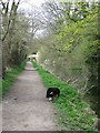
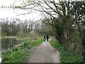
Wendover Arm: Looking along the Towpath towards Perch Bridge
A comparatively straight length of canal with the ornate Perch Bridge (No 10) in the distance.
See Image
Image: © Chris Reynolds
Taken: 1 Apr 2009
0.05 miles
2
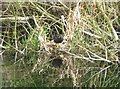
Moorhen on its nest on the Wendover Arm
Image: © Chris Reynolds
Taken: 1 Apr 2009
0.06 miles
3
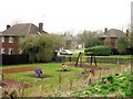
Children's Playground, High Moors, Halton
Much of the housing built on RAF Halton was built for RAF personnel.
Image: © Chris Reynolds
Taken: 2 Apr 2009
0.06 miles
4
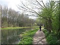
Wendover Arm : Approaching the Wides
Travelling towards Wendover this is the first you see of the canal widening out to form “The Wides”.
See Image
Image: © Chris Reynolds
Taken: 1 Apr 2009
0.10 miles
5
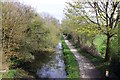
Wendover Arm: The Towpath runs past "The Wides"
At this point the free water area of “The Wides” is at its maximum.
See Image
Image: © Chris Reynolds
Taken: 1 Apr 2009
0.10 miles
6
The Wendover Arm Canal near Halton
The Wendover Arm Canal is part of the Grand Union Canal. It originally linked the Grand Union Canal at Bulbourne near Star Top End in Hertfordshire to the town of Wendover in Buckinghamshire. It has been un-navigable since 1897.
Image: © Steve Daniels
Taken: 24 Apr 2013
0.10 miles
7
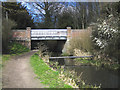
Wendover Arm: Perch Bridge (No 10) from the north
In architectural terms it is clear that this is not an original canal bridge. The original bridge would have been a humpbacked brick-built bridge with quite a steep approach on the south west side. The fancy ironwork Image, and the ornate touches in the brickwork (unnecessary in a purely functional bridge) suggest to me that it was built by Baron Alfred Rothschild – although it is not as elaborate as the other bridge he built over the canal Image
See Image
Image: © Chris Reynolds
Taken: 1 Apr 2009
0.11 miles
8
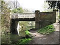
Grand Union Canal (Wendover Arm)
The disused (as can be noted from the pipe crossing!) Wendover Arm of the Grand Union Canal at the Halton Lane bridge. The canal was constructed and opened in 1793, primarily to provide water to the Tring summit of the main Grand Union Canal. However water leakage through the banks was great and despite numerous efforts at repairs and the use of the Arm for commercial purposes, it was closed in 1904.
Image: © Nigel Cox
Taken: 8 Apr 2006
0.12 miles
9
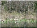
Wendover Arm: The Wides ? with nesting swan on the East bank
Image: © Chris Reynolds
Taken: 1 Apr 2009
0.12 miles
10
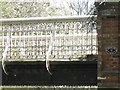
Detail of the Ironwork on the Perch Bridge
See Image
Image: © Chris Reynolds
Taken: 1 Apr 2009
0.12 miles