IMAGES TAKEN NEAR TO
The Orchard, AYLESBURY, HP22 5LN
Introduction
This page details the photographs taken nearby to The Orchard, HP22 5LN by members of the Geograph project.
The Geograph project started in 2005 with the aim of publishing, organising and preserving representative images for every square kilometre of Great Britain, Ireland and the Isle of Man.

There are currently over 7.5m images from over14,400 individuals and you can help contribute to the project by visiting https://www.geograph.org.uk
Image Map
Images are licensed for reuse under creativecommons.org/licenses/by-sa/2.0
Notes
- Clicking on the map will re-center to the selected point.
- The higher the marker number, the further away the image location is from the centre of the postcode.
Image Listing (15 Images Found)
Images are licensed for reuse under creativecommons.org/licenses/by-sa/2.0
Image
Details
Distance
1
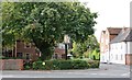
Aston Clinton: The Baptist Church
This Baptist Chapel was built in 1897 and is in Green End Street.
Image: © Nigel Cox
Taken: 8 Apr 2006
0.08 miles
2
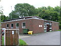
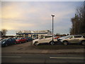
Telephone Exchange, Aston Clinton
This building, which dates from the early 1970s, is located at the far end of Putnams Drive and has the code SMAN. It provides telephone and broadband services to approximately 1,809 residential and 77 non-residential premises in Aston Clinton, plus Buckland and Drayton Beauchamp nearby. The numbering range of this TE is (01296) 63xxxx, the (01296) referring to the Aylesbury group of fourteen TEs, and its postcode is HP22 5HH.
Image: © David Hillas
Taken: 22 Jul 2008
0.09 miles
4
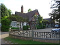
West Lodge
One of two lodges at the entrance to Aston Clinton House, country residence of Sir Anthony de Rothschild. West Lodge was home to his landscape gardener John Taylor and later Head Gardener William Warren. The estate was sold in 1923 and the lodges disposed of in 1933. The West Lodge has been a hotel since the mid 1980s
Image: © John M
Taken: 13 May 2017
0.18 miles
6
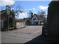
Aston Clinton: The Oak
A traditional thatched pub set back in the corner of the junction of Green End Street and Brook Street.
Image: © Nigel Cox
Taken: 8 Apr 2006
0.21 miles
7
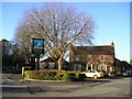
The Bell (formerly The Duck In), Aston Clinton
London Road, Aston Clinton, Aylesbury, HP22 5BP near to both the Wendover Arm of the Grand Union Canal and Aylesbury Arm of the same canal.
Image: © canalandriversidepubs co uk
Taken: 5 Feb 2010
0.22 miles
8
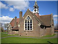
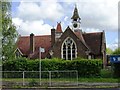
Aston Clinton: The Old School
The Old School in the grounds of the current Aston Clinton School in Twitchell Lane. The clock dates from 1887 when it was erected to commemorate Queen Victoria's Golden Jubilee.
The building is Grade II Listed and the Historic England website describes it thus:-
"Former Infants' School, 1859 by Gotto of Tring. Gothic style; purple brick with stone dressings, gable copings and kneelers. Tiled roof with fishscale bands. Central louvre with steep hipped tiled roof and terracotta finials. Square clock turret over south wing with battered tiled base, clock stage with belfry over, elaborate brackets supporting shingled spirelet with metal finial. 1-storey. South elevation has projecting wing to RH with large traceried window. Porch in angle, with pointed arched door, gable at LH end over 2-light traceried window. West gable has 3-light traceried window. North elevation has four 2-light traceried windows with gables over, pointed arched door at LH end. Built as a present for Constance, Sir Antony de Rothschilds eldest daughter, on her 16th birthday at her request."
Image: © Nigel Cox
Taken: 8 Apr 2006
0.23 miles
9
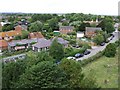
Aston Clinton from the church tower
Taken from the church tower looking northwest across Aston Clinton. The building with the little spiky turret is the old school (see Image) on the crossroads. (Supplemental photo taken across the gridline)
Image: © Rob Farrow
Taken: 8 Jul 2006
0.23 miles