IMAGES TAKEN NEAR TO
Wenwell Close, AYLESBURY, HP22 5LG
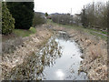
Introduction
This page details the photographs taken nearby to Wenwell Close, HP22 5LG by members of the Geograph project.
The Geograph project started in 2005 with the aim of publishing, organising and preserving representative images for every square kilometre of Great Britain, Ireland and the Isle of Man.

There are currently over 7.5m images from over14,400 individuals and you can help contribute to the project by visiting https://www.geograph.org.uk
Image Map
Images are licensed for reuse under creativecommons.org/licenses/by-sa/2.0
Notes
- Clicking on the map will re-center to the selected point.
- The higher the marker number, the further away the image location is from the centre of the postcode.
Image Listing (46 Images Found)
Images are licensed for reuse under creativecommons.org/licenses/by-sa/2.0
Image
Details
Distance
1
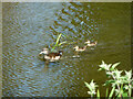
Duck and ducklings, Grand Union Canal, Wendover Arm
In the unrestored part west of Buckland Wharf. It looks like a Mandarin Duck, a non-native species but quite common.
Image: © Robin Webster
Taken: 5 Jun 2014
0.05 miles
2
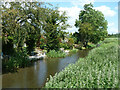
Grand Union Canal, Wendover Arm
The unrestored part west of Buckland Wharf.
Image: © Robin Webster
Taken: 5 Jun 2014
0.06 miles
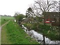
3
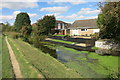
A clear bit of canal
There is a street of houses along here all backing onto the disused Wendover canal.
Different people, different methods.
Some ignore the canal completely and have a mess of weeds at the end of the garden. Some clear out their side for a bit of a water feature but leave the other side alone.
And the people here have opened the whole lot up to give a view over the fields opposite.
Image: © Des Blenkinsopp
Taken: 26 Sep 2015
0.06 miles
4
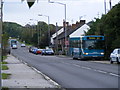
Old A41 at Buckland Wharf
A Luton to Aylesbury bus picks up a passenger at Buckland Wharf, while the service towards Luton climbs Tring Hill in the distance.
Image: © David Sands
Taken: 29 Sep 2007
0.06 miles
5
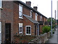
Cottages at Buckland Wharf
Victorian cottages along the old A41 at Buckland Wharf.
Image: © David Sands
Taken: 29 Sep 2007
0.08 miles
6
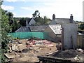
A short-lived view over the site of the Gospel Hall
The view is similar to Image which was taken in April – before the Gospel Hall was demolished. A house will soon appear where the chapel was.
Image: © Chris Reynolds
Taken: 31 Jul 2009
0.11 miles
7
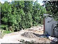
The Gospel Hall has gone, Buckland Wharf
This old chapel has now been demolished (apart for a short length of wall) and permission has been obtained to build a house on the site. The hedge is actually the steep bank into the canal.
Compare with Image – taken about 4 month's earlier.
Image: © Chris Reynolds
Taken: 31 Jul 2009
0.11 miles
8
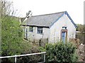
The Gospel Hall, Buckland Wharf
This tiny chapel is on the bank of the canal and faces onto the road. At the time this photograph was taken there was evidence for building work in progress. Four months later it was demolished see Image and Image
For another view before demolition see Image
Image: © Chris Reynolds
Taken: 9 Apr 2009
0.11 miles
9
Buckland Wharf
This is one of a number of old wharves along the largely disused Wendover Arm of the Grand Union Canal. A huge project is under way managed by the Wendover Arm Trust to dig out and repair the whole length of the arm and make it navigable all the way from Bulborne to Wendover. The view is to the South, where the canal passes under the old A41 near Aston Clinton.
Image: © Chris Cole
Taken: 12 Mar 2006
0.11 miles
10
Wendover Arm: The Canal West of Bridge No 6
There are no new low bridges from here to Halton Village – so once the canal has been re-opened to Buckland Wharf, and the two bridges there (No 5B & No 6) are raised navigation should be possible to Halton.
See Image
Image: © Chris Reynolds
Taken: 9 Apr 2009
0.11 miles