IMAGES TAKEN NEAR TO
Hulcott Lane, AYLESBURY, HP22 5GA
Introduction
This page details the photographs taken nearby to Hulcott Lane, HP22 5GA by members of the Geograph project.
The Geograph project started in 2005 with the aim of publishing, organising and preserving representative images for every square kilometre of Great Britain, Ireland and the Isle of Man.

There are currently over 7.5m images from over14,400 individuals and you can help contribute to the project by visiting https://www.geograph.org.uk
Image Map
Images are licensed for reuse under creativecommons.org/licenses/by-sa/2.0
Notes
- Clicking on the map will re-center to the selected point.
- The higher the marker number, the further away the image location is from the centre of the postcode.
Image Listing (6 Images Found)
Images are licensed for reuse under creativecommons.org/licenses/by-sa/2.0
Image
Details
Distance
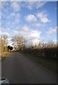
1
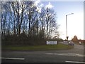
The road to Hulcott at the junction of the A418
Image: © David Howard
Taken: 11 Feb 2018
0.08 miles
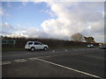
3
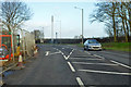
A418 towards Leighton Buzzard
Leaving the Bierton built-up area, Hulcott Lane is the right turn ahead, for Hulcott, a rather small place.
Image: © Robin Webster
Taken: 8 Dec 2019
0.10 miles
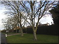
6
Gib Lane, Bierton
Looking towards Corner Farm
Image: © David Howard
Taken: 11 Feb 2018
0.22 miles