IMAGES TAKEN NEAR TO
Roundhouse Close, AYLESBURY, HP22 5FR
Introduction
This page details the photographs taken nearby to Roundhouse Close, HP22 5FR by members of the Geograph project.
The Geograph project started in 2005 with the aim of publishing, organising and preserving representative images for every square kilometre of Great Britain, Ireland and the Isle of Man.

There are currently over 7.5m images from over14,400 individuals and you can help contribute to the project by visiting https://www.geograph.org.uk
Image Map
Images are licensed for reuse under creativecommons.org/licenses/by-sa/2.0
Notes
- Clicking on the map will re-center to the selected point.
- The higher the marker number, the further away the image location is from the centre of the postcode.
Image Listing (41 Images Found)
Images are licensed for reuse under creativecommons.org/licenses/by-sa/2.0
Image
Details
Distance
1
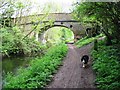
Grand Union Canal, Wendover Arm
East of Wellonhead Bridge (7). This is on the unnavigable part of the arm, currently only used as a water conduit with a lowered water level.
Image: © Robin Webster
Taken: 5 Jun 2014
0.04 miles
2
Grand Union Canal
Grand Union Canal Wendover Arm at Wellonhead Bridge
Image: © Shaun Ferguson
Taken: 20 Mar 2010
0.04 miles
3
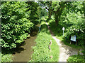
Wendover Arm: Looking West towards Wellonhead Bridge (No 7)
The tree is heavily infested with ivy and long festoons of it hang from the branch over the canal.
See Image
Image: © Chris Reynolds
Taken: 19 Apr 2009
0.05 miles
4
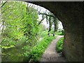
Wendover Arm: Looking East from under Bridge No 7
See Image
Image: © Chris Reynolds
Taken: 19 Apr 2009
0.05 miles
5
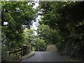
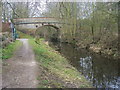
Stablebridge Road crosses Wellonhead Bridge
Image: © Steve Daniels
Taken: 31 Aug 2020
0.05 miles
6
Wellonhead Bridge
This is Bridge 7 of the Wendover Arm, Grand Union Canal. This is on the unnavigable part of the arm, currently only used as a water conduit with a lowered water level.
Image: © Robin Webster
Taken: 5 Jun 2014
0.06 miles
7
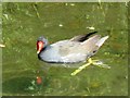
A Moorhen on the Wendover Arm of the Grand Union Canal
One of the delights of the disused section of the Wendover Arm is that there is a good footpath close to clear running water – which makes it an excellent place to watch the various species of water birds – and even get close enough to take modest photographs of the birds with a pocket-sized camera.
Image: © Chris Reynolds
Taken: 19 Apr 2009
0.07 miles
8
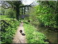
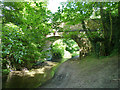
Wendover Arm: Wellonhead Bridge (No 7) from the East
Note the ends of the iron tie-bars inserted to strengthen the bridge (which has a weight limit restriction) and also the decayed brickwork. The bridge is so narrow that traffic cannot pass – and there are traffic lights.
See Image about the name of the bridge.
See Image
Image: © Chris Reynolds
Taken: 19 Apr 2009
0.07 miles
9
Water Starwort in the Wendover Arm of the Grand Union Canal
The clear water of the disused section of the canal contains large quantities of waterweed – but normally it is difficult to photograph because of reflections. This shot has been taken under Wellonhead Bridge to reduce the reflections, allowing the weed to be seen more clearly.
Image: © Chris Reynolds
Taken: 17 May 2009
0.07 miles
10
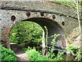
Wendover Arm of the Grand Union Canal: Wellonhead Bridge (No 7) from the West
The road over the Canal is called Stablebridge Road, and may have been given the name because it was the way to the stables associated with the house in Green Park in Victorian times, The bridge was built when the canal was opened in 1797. But why is the bridge called “Wellonhead Bridge”? Did a small stream called the Wellon rise near here before the canal was built? A Google search has revealed nothing so can you help?
See Image
Image: © Chris Reynolds
Taken: 19 Apr 2009
0.07 miles