IMAGES TAKEN NEAR TO
Green End Street, AYLESBURY, HP22 5EU
Introduction
This page details the photographs taken nearby to Green End Street, HP22 5EU by members of the Geograph project.
The Geograph project started in 2005 with the aim of publishing, organising and preserving representative images for every square kilometre of Great Britain, Ireland and the Isle of Man.

There are currently over 7.5m images from over14,400 individuals and you can help contribute to the project by visiting https://www.geograph.org.uk
Image Map
Images are licensed for reuse under creativecommons.org/licenses/by-sa/2.0
Notes
- Clicking on the map will re-center to the selected point.
- The higher the marker number, the further away the image location is from the centre of the postcode.
Image Listing (3 Images Found)
Images are licensed for reuse under creativecommons.org/licenses/by-sa/2.0
Image
Details
Distance
1
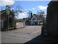
Aston Clinton: The Oak
A traditional thatched pub set back in the corner of the junction of Green End Street and Brook Street.
Image: © Nigel Cox
Taken: 8 Apr 2006
0.10 miles
2
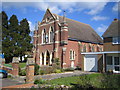
Aston Clinton: The Baptist Church
This Baptist Chapel was built in 1897 and is in Green End Street.
Image: © Nigel Cox
Taken: 8 Apr 2006
0.14 miles
3
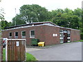
Telephone Exchange, Aston Clinton
This building, which dates from the early 1970s, is located at the far end of Putnams Drive and has the code SMAN. It provides telephone and broadband services to approximately 1,809 residential and 77 non-residential premises in Aston Clinton, plus Buckland and Drayton Beauchamp nearby. The numbering range of this TE is (01296) 63xxxx, the (01296) referring to the Aylesbury group of fourteen TEs, and its postcode is HP22 5HH.
Image: © David Hillas
Taken: 22 Jul 2008
0.19 miles