IMAGES TAKEN NEAR TO
Newville, AYLESBURY, HP22 4NP
Introduction
This page details the photographs taken nearby to Newville, HP22 4NP by members of the Geograph project.
The Geograph project started in 2005 with the aim of publishing, organising and preserving representative images for every square kilometre of Great Britain, Ireland and the Isle of Man.

There are currently over 7.5m images from over14,400 individuals and you can help contribute to the project by visiting https://www.geograph.org.uk
Image Map
Images are licensed for reuse under creativecommons.org/licenses/by-sa/2.0
Notes
- Clicking on the map will re-center to the selected point.
- The higher the marker number, the further away the image location is from the centre of the postcode.
Image Listing (13 Images Found)
Images are licensed for reuse under creativecommons.org/licenses/by-sa/2.0
Image
Details
Distance
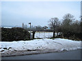
6
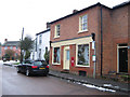
Weedon
This is the view of Weedon on entering from the SW on New Road.
Image: © Rob Farrow
Taken: 3 Jun 2006
0.16 miles
8
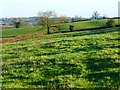
Pasture, Weedon
A hillside to the east of the village viewed from the footpath to East End.
Image: © Andrew Smith
Taken: 2 Jan 2015
0.20 miles
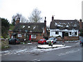
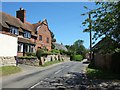
9
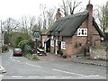
Five Elms, Weedon
The pub stands on a lane called Stockaway, which heads South towards the village pond
Image: © Chris Cole
Taken: 10 Mar 2006
0.20 miles
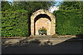
10
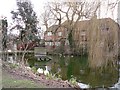
Weedon Village Pond
Viewed from Stockaway Lane, looking South West
Image: © Chris Cole
Taken: 10 Mar 2006
0.20 miles