IMAGES TAKEN NEAR TO
Church Headland Lane, AYLESBURY, HP22 4JX
Introduction
This page details the photographs taken nearby to Church Headland Lane, HP22 4JX by members of the Geograph project.
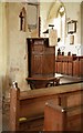
The Geograph project started in 2005 with the aim of publishing, organising and preserving representative images for every square kilometre of Great Britain, Ireland and the Isle of Man.

There are currently over 7.5m images from over14,400 individuals and you can help contribute to the project by visiting https://www.geograph.org.uk
Image Map
Images are licensed for reuse under creativecommons.org/licenses/by-sa/2.0
Notes
- Clicking on the map will re-center to the selected point.
- The higher the marker number, the further away the image location is from the centre of the postcode.
Image Listing (121 Images Found)
Images are licensed for reuse under creativecommons.org/licenses/by-sa/2.0
Image
Details
Distance
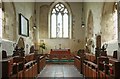
1
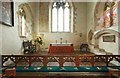
St John the Evangelist, Whitchurch - Sanctuary
Image: © John Salmon
Taken: 10 Sep 2011
0.04 miles
3
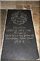
St John the Evangelist, Whitchurch - Ledger slab
Image: © John Salmon
Taken: 10 Sep 2011
0.04 miles
4
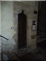
St John the Evangelist, Whitchurch: ancient door
Image: © Basher Eyre
Taken: 6 Sep 2011
0.04 miles
5
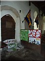
St John the Evangelist, Whitchurch: display
Image: © Basher Eyre
Taken: 6 Sep 2011
0.04 miles
6
St John the Evangelist, Whitchurch - East end
Image: © John Salmon
Taken: 10 Sep 2011
0.04 miles
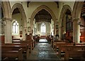
7
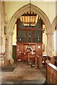
St John the Evangelist, Whitchurch - Chancel
Image: © John Salmon
Taken: 10 Sep 2011
0.04 miles
8
St John the Evangelist, Whitchurch - Sanctuary
Image: © John Salmon
Taken: 10 Sep 2011
0.04 miles
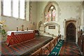
9
St John the Evangelist, Whitchurch - Pulpit
Image: © John Salmon
Taken: 10 Sep 2011
0.04 miles
10
St John the Evangelist, Whitchurch - Organ
Image: © John Salmon
Taken: 10 Sep 2011
0.04 miles