IMAGES TAKEN NEAR TO
Lower Road, AYLESBURY, HP22 4DZ
Introduction
This page details the photographs taken nearby to Lower Road, HP22 4DZ by members of the Geograph project.
The Geograph project started in 2005 with the aim of publishing, organising and preserving representative images for every square kilometre of Great Britain, Ireland and the Isle of Man.

There are currently over 7.5m images from over14,400 individuals and you can help contribute to the project by visiting https://www.geograph.org.uk
Image Map
Images are licensed for reuse under creativecommons.org/licenses/by-sa/2.0
Notes
- Clicking on the map will re-center to the selected point.
- The higher the marker number, the further away the image location is from the centre of the postcode.
Image Listing (45 Images Found)
Images are licensed for reuse under creativecommons.org/licenses/by-sa/2.0
Image
Details
Distance
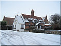
1
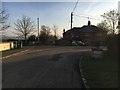
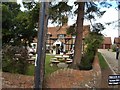
Lower Road
Lower Road by a modest roadside war memorial
Image: © Shaun Ferguson
Taken: 4 Jan 2019
0.03 miles
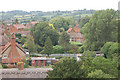
5
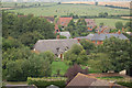
North east view of Hardwick.
Viewed from church tower.
Image: © John Firth
Taken: 25 Jul 2008
0.07 miles
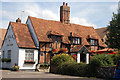
7
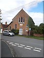
Hardwick old chapel
Now a residential property
Image: © John Firth
Taken: 22 Sep 2013
0.09 miles
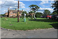
10
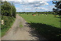
Cattle by the footpath to Aston Abbots
Image: © Philip Jeffrey
Taken: 19 Jul 2020
0.09 miles