IMAGES TAKEN NEAR TO
Quainton, AYLESBURY, HP22 4DJ
Introduction
This page details the photographs taken nearby to HP22 4DJ by members of the Geograph project.
The Geograph project started in 2005 with the aim of publishing, organising and preserving representative images for every square kilometre of Great Britain, Ireland and the Isle of Man.

There are currently over 7.5m images from over14,400 individuals and you can help contribute to the project by visiting https://www.geograph.org.uk
Image Map
Images are licensed for reuse under creativecommons.org/licenses/by-sa/2.0
Notes
- Clicking on the map will re-center to the selected point.
- The higher the marker number, the further away the image location is from the centre of the postcode.
Image Listing (8 Images Found)
Images are licensed for reuse under creativecommons.org/licenses/by-sa/2.0
Image
Details
Distance
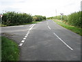
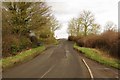
1
Deep ditch alongside road
Grange Farm in the distance
Image: © Bikeboy
Taken: 2 Jan 2015
0.05 miles
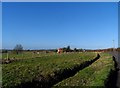
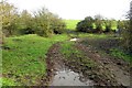
2
Fish Pond and sheep by Grange farm
By the Bernwood Way Fish Pond and sheep by Grange farm
Image: © Shaun Ferguson
Taken: 21 Sep 2007
0.10 miles
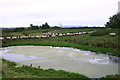
4
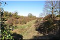
Old Metropolitan Railway line at Shipton Lee
The course of the old Metropolitan Railway line from Quainton Road to Verney Junction at Shipton Lee. The line closed to passengers in the 1930's and freight in the late 1940's.
Image: © Bob Walters
Taken: 22 Oct 2018
0.24 miles
7
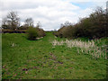
Dismantled Railway near Shipton Lee
Looking towards Verney Junction. View taken from the footpath by Lee Bridge Cottage. The road bridge over the line here has been replaced by an earth embankment, which is in the next square - SP7321.
Image: © Martin Addison
Taken: 4 Apr 2007
0.24 miles