IMAGES TAKEN NEAR TO
Quainton, AYLESBURY, HP22 4DE
Introduction
This page details the photographs taken nearby to HP22 4DE by members of the Geograph project.
The Geograph project started in 2005 with the aim of publishing, organising and preserving representative images for every square kilometre of Great Britain, Ireland and the Isle of Man.

There are currently over 7.5m images from over14,400 individuals and you can help contribute to the project by visiting https://www.geograph.org.uk
Image Map
Images are licensed for reuse under creativecommons.org/licenses/by-sa/2.0
Notes
- Clicking on the map will re-center to the selected point.
- The higher the marker number, the further away the image location is from the centre of the postcode.
Image Listing (11 Images Found)
Images are licensed for reuse under creativecommons.org/licenses/by-sa/2.0
Image
Details
Distance
1
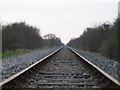
Railway line near Woodlands Farm
This railway line was once part of the Great Central Railway, which when it opened in 1899 was the last main line double track railway to be built. The line ran between Sheffield, Nottingham and London Marylebone. Much of the line was closed in 1966, but this single track stretch between Quainton Road and Claydon Junction remains. It is used by freight trains from London, four a day each way, carrying containerised household waste to the landfill site at Calvert just before Claydon Junction. This view looking north-west is towards the junction about 5km away.
Image: © Andy Gryce
Taken: 25 Mar 2007
0.07 miles
2
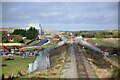
HS2 works near Greatmoor
The view towards Calvert from near Woodlands Farm. HS2 will pass between the Aylesbury to Calvert line and the new black 'haul road' that has been built alongside the farm. Haul roads have been built at many sites along HS2 to allow contractor's access to the new construction. Greatmoor EfW (Energy from Waste) incinerator lies beyond the farm buildings. The Calvert line will also be upgraded for East West Railway passenger trains to London when that part of the project is approved.
Image: © Bob Walters
Taken: 25 Oct 2021
0.08 miles
3
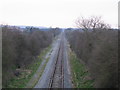
Railway line near Woodlands Farm 2
This railway line was once part of the Great Central Railway, which when it opened in 1899 was the last main line twin track railway to be built, see Image This view looking north-west and taken from a road bridge is of the remaining single track section going towards Claydon Junction 5km away. On the left behind the trees are the buildings of Woodlands Farm.
Image: © Andy Gryce
Taken: 25 Mar 2007
0.09 miles
4
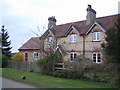
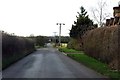
Woodlands Cottages near Quainton
These two isolated semi-detached brick built cottages lie on the north side of the C road that runs from Shipton Lee to Edgcott. A lane at the left hand end of the cottages leads to Woodlands Farm.
Image: © Andy Gryce
Taken: 25 Mar 2007
0.18 miles
6
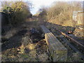
Dismantled Railway
Dismantled Railway still with some of the track on the bridge near North Farm
Image: © Shaun Ferguson
Taken: 19 Feb 2010
0.21 miles
7
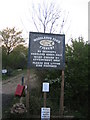
Noticeboard, Woodlands Farm Fishery
This fishing lake, Image, is near to Woodlands Farm which is off the Edgcott Road. Amongst the other very sensible rules for anglers is no playing of loud music, appropriate behaviour to be adhered to at all times, all rubbish to be taken away. And good care is taken of the fish as well - nets to be dipped on entry, no sacking of fish, a maximum of 2 rods only, and unhooking mats must be used.
And if you venture here at night a maximum of 10 anglers is allowed and you will be locked in until the following morning!
Image: © Andy Gryce
Taken: 21 Apr 2007
0.21 miles
8
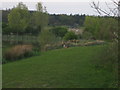
Fishing Lake, Woodlands Farm Fishery
This is the edge of a lake for coarse fishing close to Woodlands Farm. The lake holds carp, roach, rudd, bream and perch and the fishery has been established for over 15 years.
Image: © Andy Gryce
Taken: 21 Apr 2007
0.22 miles
9
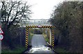
Former railway bridge over the road to Edgcott
The bridge now carries a road to Kingswood.
Image: © Steve Daniels
Taken: 14 Jan 2015
0.23 miles
10
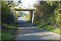
Bridge on route of old railway
The route of this part of the line has been converted to a private road in connection with waste disposal plant nearby. The bridge appears to have been replaced for this purpose. The railway was the Great Central link to its approach to London via High Wycombe, a joint route with the GWR.
Image: © Robin Webster
Taken: 20 Oct 2018
0.24 miles