IMAGES TAKEN NEAR TO
Quainton, AYLESBURY, HP22 4DB
Introduction
This page details the photographs taken nearby to HP22 4DB by members of the Geograph project.
The Geograph project started in 2005 with the aim of publishing, organising and preserving representative images for every square kilometre of Great Britain, Ireland and the Isle of Man.

There are currently over 7.5m images from over14,400 individuals and you can help contribute to the project by visiting https://www.geograph.org.uk
Image Map
Images are licensed for reuse under creativecommons.org/licenses/by-sa/2.0
Notes
- Clicking on the map will re-center to the selected point.
- The higher the marker number, the further away the image location is from the centre of the postcode.
Image Listing (14 Images Found)
Images are licensed for reuse under creativecommons.org/licenses/by-sa/2.0
Image
Details
Distance
1
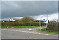
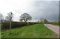
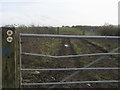
Farm buildings at the crossroads
The crossroads south of Quainton Road, ominous clouds overhead.
Image: © E Gammie
Taken: 3 Apr 2011
0.06 miles
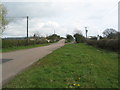
3
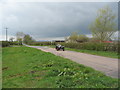
Crossroads, Station Road
A Morgan three-wheeler approaches the Buckinghamshire Railway Centre from the south, the driver probably relieved those clouds haven't released their load...yet.
Image: © E Gammie
Taken: 3 Apr 2011
0.10 miles
4
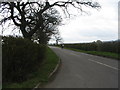
Eastwards from the crossroads
Cyclists approaching the crossroads south of Quainton Road.
Image: © E Gammie
Taken: 3 Apr 2011
0.10 miles
5
Crossroads, Station Road
Looking towards the crossroads south of the railway. A footpath marker for the Brill Tramway walk on the left.
Image: © E Gammie
Taken: 3 Apr 2011
0.11 miles
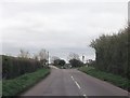
6
Station Road, Quainton
Looking from the crossroads towards the bridge over the railway at Quainton Road. To the right is the former line of the road which crossed the railway via a level crossing before the bridge was constructed in 1896. The road sign warns of pedestrians as there is no footway over the bridge, although there is just about enough verge to stand out of the roadway.
Image: © E Gammie
Taken: 3 Apr 2011
0.20 miles
7
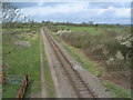
Rail line to Calvert landfill
Looking westward from the road overbridge near Quainton Road. Blackthorn in flower in the hedgerow.
Image: © E Gammie
Taken: 3 Apr 2011
0.22 miles
8
Quainton: Railway line to the Calvert landfill site
This line was opened in 1868 by the Aylesbury and Buckingham Railway and absorbed into the Metropolitan Railway in 1891. It eventually closed for passenger traffic in 1963 but is still open today for freight transfers of household waste from London to the Calvert landfill site.
The original station arrangements here were that Station Road crossed the line by a level crossing with the original Quaintonroad station on the north-west side of the level crossing. However in 1896 the Metropolitan Railway rebuilt the station to the south-east of the level crossing with the crossing being replaced by the current bridge from which this photo was taken. While the bridge was built over the former station the rough land to the left in this photograph would have housed the end of the platform and a couple of sidings.
Image: © Nigel Cox
Taken: 3 May 2009
0.22 miles
9
Tramway Trail
Off the road to Quainton the tramway trail towards Waddesdon
Image: © Shaun Ferguson
Taken: 23 Jan 2016
0.23 miles
10
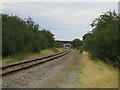
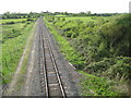
Railway line to Quainton Road Station 3
This single track railway line, which was once part of the Great Central Railway, the last main line twin track railway to be built, is now used by freight trains from Brentford in London carrying containerised household waste to the landfill site at Calvert, see Image, which is 6.5 km behind the camera.
Here looking south-east, the road bridge in the distance is for the C road between Westcott and Quainton. Beyond the bridge can just be seen Quainton Road station, where the Buckinghamshire Railway Centre is based, http://www.bucksrailcentre.org/about_us.html. The preserved railway operates short stretches of track within the 25 acre centre, but there are no passenger services between Quainton Road and the town of Aylesbury, which is 9km further on.
Image: © Andy Gryce
Taken: 17 Aug 2008
0.23 miles