IMAGES TAKEN NEAR TO
Berryfields Gated Road, AYLESBURY, HP22 4AA
Introduction
This page details the photographs taken nearby to Berryfields Gated Road, HP22 4AA by members of the Geograph project.
The Geograph project started in 2005 with the aim of publishing, organising and preserving representative images for every square kilometre of Great Britain, Ireland and the Isle of Man.

There are currently over 7.5m images from over14,400 individuals and you can help contribute to the project by visiting https://www.geograph.org.uk
Image Map (Loading...)


Getting Data...Please wait
Leaflet Map data © OpenStreetMap
Images are licensed for reuse under creativecommons.org/licenses/by-sa/2.0
Notes
- Clicking on the map will re-center to the selected point.
- The higher the marker number, the further away the image location is from the centre of the postcode.
Image Listing (1 Images Found)
Images are licensed for reuse under creativecommons.org/licenses/by-sa/2.0
Image
Details
Distance
1
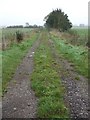
Track to D.M.V.
DMV is an abbreviation for Deserted Mediæval Village. There are several of these DMVs around this area, some with considerable earthworks betraying their former existence. This track leads for several hundred yards to a moat - presumably originally belonging to the manor house in the village.
Image: © Rob Farrow
Taken: 13 Oct 2006
0.21 miles