IMAGES TAKEN NEAR TO
Lower Road, AYLESBURY, HP21 9DR
Introduction
This page details the photographs taken nearby to Lower Road, HP21 9DR by members of the Geograph project.
The Geograph project started in 2005 with the aim of publishing, organising and preserving representative images for every square kilometre of Great Britain, Ireland and the Isle of Man.

There are currently over 7.5m images from over14,400 individuals and you can help contribute to the project by visiting https://www.geograph.org.uk
Image Map
Images are licensed for reuse under creativecommons.org/licenses/by-sa/2.0
Notes
- Clicking on the map will re-center to the selected point.
- The higher the marker number, the further away the image location is from the centre of the postcode.
Image Listing (7 Images Found)
Images are licensed for reuse under creativecommons.org/licenses/by-sa/2.0
Image
Details
Distance
1
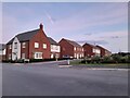
New development by Stoke Mandeville Hospital
The estate is called Harbourne Manor
Image: © David Howard
Taken: 10 Oct 2021
0.14 miles
2
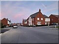
New development by Stoke Mandeville Hospital
The estate is called Harborne Manor
Image: © David Howard
Taken: 10 Oct 2021
0.14 miles
3
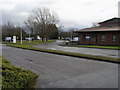
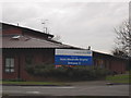
Entrance to Stoke Mandeville Hospital
Entrance by ambulance station to Stoke Mandeville Hospital
Image: © Shaun Ferguson
Taken: 23 Jan 2009
0.19 miles
4
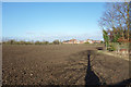
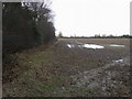
Farmland at Stoke Mandeville
A couple of footpaths cross this field, both ploughed up at the moment, making very sticky going in this clay soil.
Image: © Des Blenkinsopp
Taken: 14 Dec 2017
0.21 miles
6
Footpath off Lower Road
Footpath to Hall End off Lower Road
Image: © Shaun Ferguson
Taken: 23 Jan 2009
0.22 miles
7
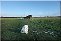
Last of the Snow
There was quite a snowstorm in mid December 2017, bringing the usual chaos. A few days later it had vanished from round here, apart from a few reminders like this, probably the remains of a snowman.
Image: © Des Blenkinsopp
Taken: 14 Dec 2017
0.23 miles