IMAGES TAKEN NEAR TO
Nursery Close, AYLESBURY, HP21 8XA
Introduction
This page details the photographs taken nearby to Nursery Close, HP21 8XA by members of the Geograph project.
The Geograph project started in 2005 with the aim of publishing, organising and preserving representative images for every square kilometre of Great Britain, Ireland and the Isle of Man.

There are currently over 7.5m images from over14,400 individuals and you can help contribute to the project by visiting https://www.geograph.org.uk
Image Map
Images are licensed for reuse under creativecommons.org/licenses/by-sa/2.0
Notes
- Clicking on the map will re-center to the selected point.
- The higher the marker number, the further away the image location is from the centre of the postcode.
Image Listing (25 Images Found)
Images are licensed for reuse under creativecommons.org/licenses/by-sa/2.0
Image
Details
Distance
1
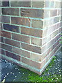
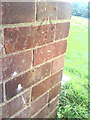
Benchmark on #38 Grenville Road
Ordnance Survey cut mark benchmark described on the Bench Mark Database at http://www.bench-marks.org.uk/bm35837
Image: © Roger Templeman
Taken: 27 Oct 2010
0.10 miles
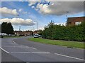
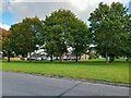
3
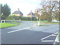
Roundabout where Carrington Road crosses Churchill Avenue
This roundabout has a beech tree, the next one to the SE a church.
Image: © Roger Templeman
Taken: 27 Oct 2010
0.12 miles
4
Benchmark on #57 Lee Road
Ordnance Survey cut mark benchmark described on the Bench Mark Database at http://www.bench-marks.org.uk/bm23348
Image: © Roger Templeman
Taken: 27 Oct 2010
0.12 miles
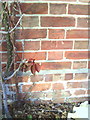
5
Benchmark on #57 Churchill Avenue
Ordnance Survey cut mark benchmark described on the Bench Mark Database at http://www.bench-marks.org.uk/bm35832
Image: © Roger Templeman
Taken: 27 Oct 2010
0.12 miles
8
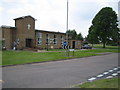
Aylesbury: Church of The Good Shepherd
The Church's website http://www.steveweb.me.uk/cgs/ describes itself as an informal evangelical Anglican Church. It has a curious location being the only building on the large Southcourt "squareabout", or Church Square as it is known.
Image: © Nigel Cox
Taken: 7 Jun 2006
0.17 miles
9
Aylesbury: Guardian Angels Roman Catholic Church
The church is on the Southcourt estate, on Chaloner Road.
Image: © Nigel Cox
Taken: 20 Jul 2008
0.18 miles
10
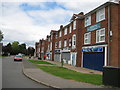
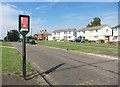
Aylesbury: Hampden Gardens shops, Southcourt
The Southcourt estate was built by the local council between the 1920s and 1950s and is epitomised by the wide spaces between the houses and by areas of public greens. This is the community shopping parade in Hampden Gardens, named after Sir John Hampden, a Parliamentary politician closely associated with Aylesbury who died as a result of wounds received during a Civil War battle in 1643.
Image: © Nigel Cox
Taken: 20 Jul 2008
0.18 miles