IMAGES TAKEN NEAR TO
St. Marks Road, AYLESBURY, HP21 8RH
Introduction
This page details the photographs taken nearby to St. Marks Road, HP21 8RH by members of the Geograph project.
The Geograph project started in 2005 with the aim of publishing, organising and preserving representative images for every square kilometre of Great Britain, Ireland and the Isle of Man.

There are currently over 7.5m images from over14,400 individuals and you can help contribute to the project by visiting https://www.geograph.org.uk
Image Map (Loading...)


Getting Data...Please wait
Leaflet Map data © OpenStreetMap
Images are licensed for reuse under creativecommons.org/licenses/by-sa/2.0
Notes
- Clicking on the map will re-center to the selected point.
- The higher the marker number, the further away the image location is from the centre of the postcode.
Image Listing (18 Images Found)
Images are licensed for reuse under creativecommons.org/licenses/by-sa/2.0
Image
Details
Distance
1
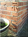
Benchmark on #23 Oak Green
Ordnance Survey cut mark benchmark described on the Bench Mark Database at http://www.bench-marks.org.uk/bm35845
Image: © Roger Templeman
Taken: 27 Oct 2010
0.03 miles
2
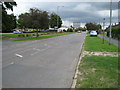
Aylesbury: Prebendal Avenue, California
The boulders separating the road from the grass are a common sight in Aylesbury and have been introduced to deter the travelling community from setting up camp on the greens. As ever the County Tower looms large...
Image: © Nigel Cox
Taken: 20 Jul 2008
0.05 miles
3
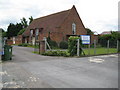
Aylesbury: St Mark's United Reformed Church
The church, which is down St Mark's Way off Prebendal Avenue, is shared between St Mark's United Reformed Church and Aylesbury Vale Community Church.
Image: © Nigel Cox
Taken: 20 Jul 2008
0.07 miles
4
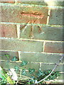
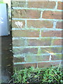
Benchmark on #160 Prebendal Avenue
Ordnance Survey cut mark benchmark described on the Bench Mark Database at http://www.bench-marks.org.uk/bm35831
Image: © Roger Templeman
Taken: 27 Oct 2010
0.14 miles
5
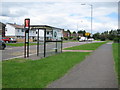
Aylesbury: Bus stop in Churchill Avenue
These distinctive Red Route bus stops and shelters are promininent items of street furniture in Aylesbury. This is the Chalgrove Walk bus stop in Churchill Avenue on the Southcourt estate.
Image: © Nigel Cox
Taken: 20 Jul 2008
0.16 miles
6
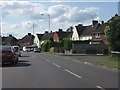
Aylesbury - Prebendal Avenue at More Avenue
Image: © Peter Whatley
Taken: 19 Jun 2012
0.17 miles
7
Benchmark on #48 Eaton Road
Ordnance Survey cut mark benchmark described on the Bench Mark Database at http://www.bench-marks.org.uk/bm35840
Image: © Roger Templeman
Taken: 27 Oct 2010
0.17 miles
9
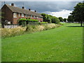
Southcourt Brook in Aylesbury
Southcourt Brook is a tributary of Bear Brook and the River Thame. The wide open green areas epitomise the design of Aylesbury's Southcourt Estate as a garden village.
Image: © Nigel Cox
Taken: 20 Jul 2008
0.18 miles
10
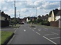
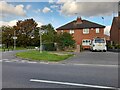
Aylesbury - Prebendal Avenue at Eaton Road
Image: © Peter Whatley
Taken: 19 Jun 2012
0.19 miles