IMAGES TAKEN NEAR TO
Churchmere Walk, AYLESBURY, HP21 8QB
Introduction
This page details the photographs taken nearby to Churchmere Walk, HP21 8QB by members of the Geograph project.
The Geograph project started in 2005 with the aim of publishing, organising and preserving representative images for every square kilometre of Great Britain, Ireland and the Isle of Man.

There are currently over 7.5m images from over14,400 individuals and you can help contribute to the project by visiting https://www.geograph.org.uk
Image Map
Images are licensed for reuse under creativecommons.org/licenses/by-sa/2.0
Notes
- Clicking on the map will re-center to the selected point.
- The higher the marker number, the further away the image location is from the centre of the postcode.
Image Listing (9 Images Found)
Images are licensed for reuse under creativecommons.org/licenses/by-sa/2.0
Image
Details
Distance
1
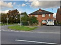
Ellen Road, Aylesbury
Junction with Cornbrook Road.
Image: © Des Blenkinsopp
Taken: 13 Sep 2016
0.06 miles

3
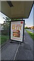
McDonald's Chicken Big Mac advert
Another McDonald's bus shelter advert depicting the Chicken Big Mac. It seems to have something suspicious on it, but it could just be remains of vandalism.
Image: © melodie
Taken: 7 May 2024
0.09 miles
4
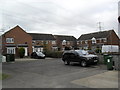
Iris Close
1990s properties, electricity lines a BMW X5 and an 8th generation Honda Civic.
Image: © Burgess Von Thunen
Taken: 21 Feb 2012
0.14 miles
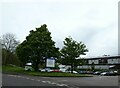
5
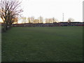
Walton Court playing field
Walton Court playing field by Hannon Road
Image: © Shaun Ferguson
Taken: 23 Jan 2009
0.18 miles
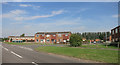
7
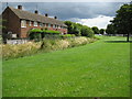
Southcourt Brook in Aylesbury
Southcourt Brook is a tributary of Bear Brook and the River Thame. The wide open green areas epitomise the design of Aylesbury's Southcourt Estate as a garden village.
Image: © Nigel Cox
Taken: 20 Jul 2008
0.23 miles