IMAGES TAKEN NEAR TO
Prebendal Avenue, AYLESBURY, HP21 8LB
Introduction
This page details the photographs taken nearby to Prebendal Avenue, HP21 8LB by members of the Geograph project.
The Geograph project started in 2005 with the aim of publishing, organising and preserving representative images for every square kilometre of Great Britain, Ireland and the Isle of Man.

There are currently over 7.5m images from over14,400 individuals and you can help contribute to the project by visiting https://www.geograph.org.uk
Image Map
Images are licensed for reuse under creativecommons.org/licenses/by-sa/2.0
Notes
- Clicking on the map will re-center to the selected point.
- The higher the marker number, the further away the image location is from the centre of the postcode.
Image Listing (41 Images Found)
Images are licensed for reuse under creativecommons.org/licenses/by-sa/2.0
Image
Details
Distance
1
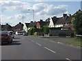
Aylesbury - Prebendal Avenue at More Avenue
Image: © Peter Whatley
Taken: 19 Jun 2012
0.05 miles
2
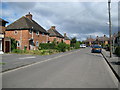
Aylesbury: Penn Road, California
California seems to have developed as the result of the construction of a printing works between Bear Brook and California Brook in Victorian times. Penn Road was the first residential street to be developed in the area, which later expanded into the massive suburban sprawl of the Southchurch estate.
Image: © Nigel Cox
Taken: 20 Jul 2008
0.08 miles
3
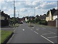
Aylesbury - Prebendal Avenue at Eaton Road
Image: © Peter Whatley
Taken: 19 Jun 2012
0.08 miles
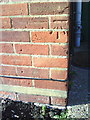
4
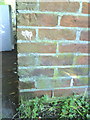
Benchmark on #48 Eaton Road
Ordnance Survey cut mark benchmark described on the Bench Mark Database at http://www.bench-marks.org.uk/bm35840
Image: © Roger Templeman
Taken: 27 Oct 2010
0.11 miles
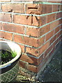
5
Benchmark on #2 More Avenue
Ordnance Survey cut mark benchmark described on the Bench Mark Database at http://www.bench-marks.org.uk/bm35846
Image: © Roger Templeman
Taken: 27 Oct 2010
0.12 miles
6
Benchmark on #23 Oak Green
Ordnance Survey cut mark benchmark described on the Bench Mark Database at http://www.bench-marks.org.uk/bm35845
Image: © Roger Templeman
Taken: 27 Oct 2010
0.12 miles
7
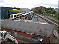
Aylesbury: Chiltern Railways' maintenance depot
Chiltern Railways use this depot at their Aylesbury terminus to undertake maintenance work on their trains. In this view on the left is unit number 168216, in the centre is number 165013, while end on is redundant coach number 51411 from a much earlier slam-door train stock unit.
The line on the right gives access to the depot from the station, but otherwise is only currently used for freight services to a landfill site further north. It was originally part of the main Great Central Railway line between London and Sheffield.
Image: © Nigel Cox
Taken: 20 Jul 2008
0.14 miles
8
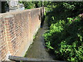
Aylesbury: California Brook
California Brook takes the excess water out of the end of the Aylesbury Arm of the Grand Union Canal at the Walton Street Basin and discharges into Bear Brook to the west of the railway station.
Image: © Nigel Cox
Taken: 20 Jul 2008
0.15 miles
10
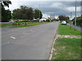
Aylesbury: Prebendal Avenue, California
The boulders separating the road from the grass are a common sight in Aylesbury and have been introduced to deter the travelling community from setting up camp on the greens. As ever the County Tower looms large...
Image: © Nigel Cox
Taken: 20 Jul 2008
0.16 miles