IMAGES TAKEN NEAR TO
Chestnut Crescent, AYLESBURY, HP21 8HU
Introduction
This page details the photographs taken nearby to Chestnut Crescent, HP21 8HU by members of the Geograph project.
The Geograph project started in 2005 with the aim of publishing, organising and preserving representative images for every square kilometre of Great Britain, Ireland and the Isle of Man.

There are currently over 7.5m images from over14,400 individuals and you can help contribute to the project by visiting https://www.geograph.org.uk
Image Map (Loading...)


Getting Data...Please wait
Leaflet Map data © OpenStreetMap
Images are licensed for reuse under creativecommons.org/licenses/by-sa/2.0
Notes
- Clicking on the map will re-center to the selected point.
- The higher the marker number, the further away the image location is from the centre of the postcode.
Image Listing (43 Images Found)
Images are licensed for reuse under creativecommons.org/licenses/by-sa/2.0
Image
Details
Distance

2

Weak bridge ahead on Old Stoke Road
The bridge carries the road over the branch between Princes Risborough and Aylesbury.
Image: © Peter Whatley
Taken: 19 Jun 2012
0.06 miles
3
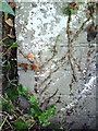
Site of benchmark on #1 Chestnut Crescent
The Ordnance Survey cut mark benchmark which is probably hidden on these bricks is described on the Bench Mark Database at http://www.bench-marks.org.uk/bm35856
Image: © Roger Templeman
Taken: 27 Oct 2010
0.06 miles
4
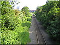
Aylesbury to Princes Risborough railway
Viewed looking towards Aylesbury railway station from the Old Stoke Road bridge in Aylesbury, there is an hourly weekday daytime service on this single track line, currently operated by Chiltern Railways. The 15-storey monolith tower of Buckinghamshire County Council's office building is visible over the trees.
Image: © Nigel Cox
Taken: 7 Jun 2006
0.06 miles
5
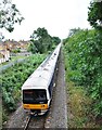
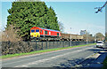
DMU No. 165031 heads towards Aylesbury
Chiltern railways DMU No.165301 heading for Aylesbury about pass under Old Stoke Road bridge. If East West Railway's plans come to fruition, this line will be used by services to London Marylebone from Milton Keynes. At present Chiltern Railways services from Aylesbury to Princes Risborough and beyond as well as freight trains for the landfill site at Calvert use this line. It is also used for HS2 aggregate trains from Gloucestershire to Calvert.
Image: © Bob Walters
Taken: 4 Aug 2019
0.06 miles
7

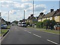
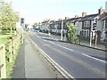
Aylesbury - Stoke Road at the junction with Mandeville Road
Image: © Peter Whatley
Taken: 19 Jun 2012
0.09 miles
8
Junction of Stoke Road and Mandeville Road
Taken from the slope down from the railway bridge.
Image: © Roger Templeman
Taken: 27 Oct 2010
0.10 miles
9
An empty 'Binliner' train returning from Calvert to Acton
Class 66 No. 66019 with an empty return 'Binliner' waste train from Calvert to Acton, West London. Several of these trains run most weekdays carrying the capital's rubbish to the landfill site at the old claypits at Calvert.
Image: © Bob Walters
Taken: 25 Feb 2019
0.10 miles
10
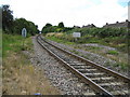
Aylesbury to Princes Risborough railway
Viewed looking in the direction of Princes Risborough from the Penn Road pedestrian crossing, the bridge from which Image was taken is visible in the distance.
Image: © Nigel Cox
Taken: 20 Jul 2008
0.11 miles