IMAGES TAKEN NEAR TO
Turnfurlong Row, AYLESBURY, HP21 7FF
Introduction
This page details the photographs taken nearby to Turnfurlong Row, HP21 7FF by members of the Geograph project.
The Geograph project started in 2005 with the aim of publishing, organising and preserving representative images for every square kilometre of Great Britain, Ireland and the Isle of Man.

There are currently over 7.5m images from over14,400 individuals and you can help contribute to the project by visiting https://www.geograph.org.uk
Image Map (Loading...)


Getting Data...Please wait
Leaflet Map data © OpenStreetMap
Images are licensed for reuse under creativecommons.org/licenses/by-sa/2.0
Notes
- Clicking on the map will re-center to the selected point.
- The higher the marker number, the further away the image location is from the centre of the postcode.
Image Listing (3 Images Found)
Images are licensed for reuse under creativecommons.org/licenses/by-sa/2.0
Image
Details
Distance
1
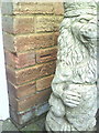
Benchmark on #53 King Edward Avenue
Ordnance Survey cut mark benchmark described on the Bench Mark Database at http://www.bench-marks.org.uk/bm35886
Image: © Roger Templeman
Taken: 2 Nov 2010
0.21 miles
2
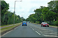
A413 Wendover Road
Towards central Aylesbury.
Image: © Robin Webster
Taken: 9 Jun 2019
0.24 miles
