IMAGES TAKEN NEAR TO
Ruskin Way, AYLESBURY, HP20 2EL
Introduction
This page details the photographs taken nearby to Ruskin Way, HP20 2EL by members of the Geograph project.
The Geograph project started in 2005 with the aim of publishing, organising and preserving representative images for every square kilometre of Great Britain, Ireland and the Isle of Man.

There are currently over 7.5m images from over14,400 individuals and you can help contribute to the project by visiting https://www.geograph.org.uk
Image Map
Images are licensed for reuse under creativecommons.org/licenses/by-sa/2.0
Notes
- Clicking on the map will re-center to the selected point.
- The higher the marker number, the further away the image location is from the centre of the postcode.
Image Listing (29 Images Found)
Images are licensed for reuse under creativecommons.org/licenses/by-sa/2.0
Image
Details
Distance
2
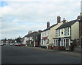
Old Milestone by the A413 in Aylesbury
Carved stone post by the A413, in parish of Aylesbury (Aylesbury Vale District), Buckingham Road; by No. 215, in Manor Park, South of by-pass roundabout, on wide well cut grass verge; between footpath and drive, on East side of road. Aylesbury square, erected by the Wendover & Buckingham turnpike trust in the 18th century.
Inscription once read:-
: (Buckingham / 16) : : (Aylesbury / 1) :
Carved benchmark lower front.
Buckinghamshire HER.
HER Number: 1358400000 https://www.heritagegateway.org.uk/Gateway/Results_Single.aspx?uid=MBC25738&resourceID=1024
Milestone Society National ID: BU_LC40
Image: © A Rosevear & J Higgins
Taken: 19 Jul 2003
0.08 miles
3
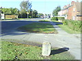
Looking north along Buckingham Road towards junction with Weedon Road
The stone on the foreground is a milestone
Image: © Roger Templeman
Taken: 25 Oct 2010
0.08 miles
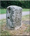
4
Benchmark on old milestone on Buckingham Road
Ordnance Survey cut mark benchmark described on the Bench Mark Database at http://www.bench-marks.org.uk/bm30729
Image: © Roger Templeman
Taken: 25 Oct 2010
0.09 miles
5
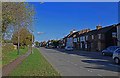
Buckingham Road, Aylesbury, Bucks
A mainly residential road but also an important through route in the town.
Image: © P L Chadwick
Taken: 27 Oct 2014
0.10 miles
6
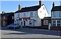
The New Zealand (1), 175 Buckingham Road, Aylesbury, Bucks
A local pub in what used to be a hamlet called New Zealand but is now part of Aylesbury.
Image
Image: © P L Chadwick
Taken: 27 Oct 2014
0.10 miles
7
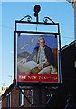
The New Zealand (2) - sign, 175 Buckingham Road, Aylesbury, Bucks
The sign shows a picture of the famous Captain James Cook (1728-1779), who made the first recorded circumnavigation of New Zealand. The picture seems to be closely based on the painting of Captain Cook by Nathaniel Dance-Holland of about 1775, which is at the National Maritime Museum in Greenwich London. Although Captain Cook has no known direct link with Aylesbury, the pub is in what was a hamlet of that name, now part of Aylesbury, and was apparently named after a breed of cow of that name.
Image
Image: © P L Chadwick
Taken: 27 Oct 2014
0.10 miles
9
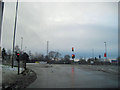
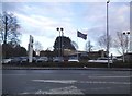
Road junction of A413 and Aylesbury Ring road
Shown on OS map as a roundabout now a traffic light controlled junction
Image: © John Firth
Taken: 28 Dec 2010
0.13 miles
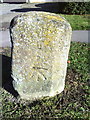
10
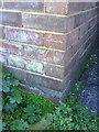
Benchmark on #21 Whaddon Chase
Ordnance Survey cut mark benchmark described on the Bench Mark Database at http://www.bench-marks.org.uk/bm35809
Image: © Roger Templeman
Taken: 25 Oct 2010
0.16 miles