IMAGES TAKEN NEAR TO
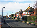
Narbeth Drive, AYLESBURY, HP20 1NU
Introduction
This page details the photographs taken nearby to Narbeth Drive, HP20 1NU by members of the Geograph project.
The Geograph project started in 2005 with the aim of publishing, organising and preserving representative images for every square kilometre of Great Britain, Ireland and the Isle of Man.

There are currently over 7.5m images from over14,400 individuals and you can help contribute to the project by visiting https://www.geograph.org.uk
Image Map
Images are licensed for reuse under creativecommons.org/licenses/by-sa/2.0
Notes
- Clicking on the map will re-center to the selected point.
- The higher the marker number, the further away the image location is from the centre of the postcode.
Image Listing (50 Images Found)
Images are licensed for reuse under creativecommons.org/licenses/by-sa/2.0
Image
Details
Distance
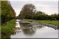
2
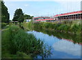
Construction work next to the canal
The Aylesbury Arm is six and a quarter miles long and has sixteen locks. It runs west from Marsworth Junction to the centre of Aylesbury.
Image: © Mat Fascione
Taken: 16 Aug 2015
0.16 miles
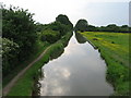
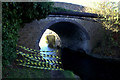
4
Grand Union Canal: Aylesbury Arm: Reach at Bridge No 16
The canal was frozen over in this view looking westwards from Bridge Number 16.
Image: © Nigel Cox
Taken: 6 Feb 2015
0.17 miles
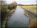
5
Aylesbury arm bridge 16
The towpath underneath the bridge has collapsed so it is necessary to take a short diversion around the top.
Image: © Robert Eva
Taken: 25 Nov 2016
0.18 miles
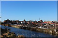
6
The Grand Union Canal entering Aylesbury
The Grand Union Canal Aylesbury Arm was completed in 1815 and runs from Marsworth to Aylesbury.
Image: © Steve Daniels
Taken: 5 May 2013
0.19 miles
7
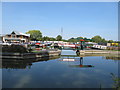
Aylesbury Circus Field Marina
Aylesbury Canal Society opened their new marina in August 2013. There is a clubhouse, on the left of the photo.
Image: © David Hawgood
Taken: 8 Sep 2014
0.19 miles
8
Construction work by the canal
Housing development on the edge of Aylesbury between bridges 16 and 16A
Image: © Robert Eva
Taken: 25 Nov 2016
0.19 miles
9
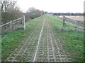
Broughton: Bear Brook Flood Storage Area Bund
Bear Brook has always been prone to bursting its banks, and, with the increasing residential development of Aylesbury, it became necessary in the 1990s to control any flood event by storing potential flood water upstream of the town. This long straight bund, which is about 400 metres long, forms the right side of the flood storage area, and follows the Aylesbury Arm of the Grand Union Canal. The canal is to the left, beyond the bushes in this view, and the flood storage area is to the right. The top surface of the bund is formed of "grasscrete" slabs, which are blocks of concrete with large holes in. The holes in the slabs enable grass to grow through to give a natural appearance, but the blocks themselves are still strong enough to provide a surface on which maintenance vehicles can be driven.
For a view taken 6 minutes later from the other end of the bund and in completely different weather conditions please see Image
Image: © Nigel Cox
Taken: 1 Dec 2013
0.19 miles
10

Horses by the Aylesbury Arm, Grand Union Canal
The horses are in one of the first fields on the outskirts of Aylesbury.
Image: © David Hawgood
Taken: 8 Sep 2014
0.19 miles