IMAGES TAKEN NEAR TO
Stocklake, AYLESBURY, HP20 1DN
Introduction
This page details the photographs taken nearby to Stocklake, HP20 1DN by members of the Geograph project.
The Geograph project started in 2005 with the aim of publishing, organising and preserving representative images for every square kilometre of Great Britain, Ireland and the Isle of Man.

There are currently over 7.5m images from over14,400 individuals and you can help contribute to the project by visiting https://www.geograph.org.uk
Image Map
Images are licensed for reuse under creativecommons.org/licenses/by-sa/2.0
Notes
- Clicking on the map will re-center to the selected point.
- The higher the marker number, the further away the image location is from the centre of the postcode.
Image Listing (64 Images Found)
Images are licensed for reuse under creativecommons.org/licenses/by-sa/2.0
Image
Details
Distance
1
Aylesbury: Trackbed of the former railway to Cheddington
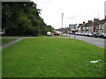
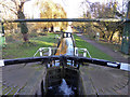
It's difficult to visualize now but this is the trackbed of the long-dismantled former London & North Western Railway's Cheddington to Aylesbury branch line. The railway was built as long ago as 1839, but was an early pre-Beeching casualty of closure, passenger services having been terminated in 1953 and goods in 1964. The railway ran dead straight from just outside Aylesbury to just outside Cheddington, and it ran here from the photographer's position towards the white car. The line here was double-tracked at the approach to Aylesbury High Street station.
Stocklake is the road on the right. More houses must have been built along Stocklake after the old photograph was taken.
Image: © Nigel Cox
Taken: 20 Jul 2008
0.05 miles
2
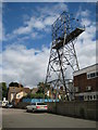
Aylesbury: Stocklake Industrial Estate electricity pylon
This is the terminal pylon at the end of a short high voltage electricity distribution line from a substation near Burcott. This type of tower is unusual in having a permanent maintenance platform. The houses in the background are on the road called Stocklake.
Image: © Nigel Cox
Taken: 20 Jul 2008
0.09 miles
3
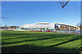
Aqua Vale Swimming & Fitness Centre, Aylesbury
Image: © Robin Webster
Taken: 28 Dec 2017
0.12 miles
5
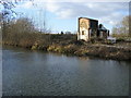
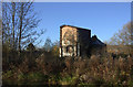
Remains of building
Looking across Grand Union Canal Aylesbury Arm to the remain of a building on Osier Way
Image: © Shaun Ferguson
Taken: 23 Jan 2009
0.15 miles
6
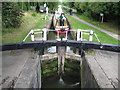
Grand Union Canal: Aylesbury Arm: Hills and Partridges Lock
Hills and Partridges, after whom this lock is named, were flour millers based at the nearby Walton Mill. The lock is Number 16 on the Aylesbury Arm and is also Aylesbury Bottom Lock. This view was taken from the Park Street bridge and the narrowboat is Jemal of Aylesbury.
Image: © Nigel Cox
Taken: 20 Jul 2008
0.16 miles
7
Aylesbury Arm: Hills and Partridges Lock (No 16)
Image: © Chris Reynolds
Taken: 14 Aug 2009
0.16 miles
8
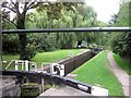
Grand Union Canal: Aylesbury Arm: Hills and Partridges Lock Number 16
Please see Image for an explanation of the name and a view from the same location six years previously. Apart from the growth of vegetation on the left side lock gate nothing has changed.
Image: © Nigel Cox
Taken: 3 Sep 2014
0.16 miles
9
Bottom lock, Aylesbury Arm, Grand Union Canal
The last of sixteen narrow locks falling from the main line.
Image: © Robin Webster
Taken: 28 Dec 2017
0.16 miles
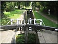
10
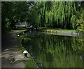
Approaching Aylesbury Bottom Lock No 16
The lock is next to Park Street Bridge No 17 on the Aylesbury Arm of the Grand Union Canal.
The Aylesbury Arm is six and a quarter miles long and has sixteen locks. It runs west from Marsworth Junction to the centre of Aylesbury.
Image: © Mat Fascione
Taken: 16 Aug 2015
0.16 miles