1
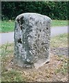
Benchmark on old milestone on Buckingham Road
Ordnance Survey cut mark benchmark described on the Bench Mark Database at http://www.bench-marks.org.uk/bm30729
Image: © Roger Templeman
Taken: 25 Oct 2010
0.04 miles
2
Old Milestone by the A413 in Aylesbury
Carved stone post by the A413, in parish of Aylesbury (Aylesbury Vale District), Buckingham Road; by No. 215, in Manor Park, South of by-pass roundabout, on wide well cut grass verge; between footpath and drive, on East side of road. Aylesbury square, erected by the Wendover & Buckingham turnpike trust in the 18th century.
Inscription once read:-
: (Buckingham / 16) : : (Aylesbury / 1) :
Carved benchmark lower front.
Buckinghamshire HER.
HER Number: 1358400000 https://www.heritagegateway.org.uk/Gateway/Results_Single.aspx?uid=MBC25738&resourceID=1024
Milestone Society National ID: BU_LC40
Image: © A Rosevear & J Higgins
Taken: 19 Jul 2003
0.04 miles
3
Stratstone Lane Rover, Aylesbury
Image: © David Howard
Taken: 4 Feb 2018
0.05 miles
4
Looking north along Buckingham Road towards junction with Weedon Road
The stone on the foreground is a milestone
Image: © Roger Templeman
Taken: 25 Oct 2010
0.05 miles
5
Road junction of A413 and Aylesbury Ring road
Shown on OS map as a roundabout now a traffic light controlled junction
Image: © John Firth
Taken: 28 Dec 2010
0.06 miles
6
The New Zealand on Buckingham Road
Image: © John Firth
Taken: 20 Mar 2012
0.08 miles
7
Buckingham Road crosses Weedon Road
Aylesbury town centre is to the right.
Image: © Steve Daniels
Taken: 14 Jul 2013
0.08 miles
8
Buckingham Road, Aylesbury, Bucks
A mainly residential road but also an important through route in the town.
Image: © P L Chadwick
Taken: 27 Oct 2014
0.09 miles
9
Houses on Weedon Road, Aylesbury
Image: © David Howard
Taken: 11 Feb 2018
0.10 miles
10
Benchmark on #21 Whaddon Chase
Ordnance Survey cut mark benchmark described on the Bench Mark Database at http://www.bench-marks.org.uk/bm35809
Image: © Roger Templeman
Taken: 25 Oct 2010
0.10 miles


