IMAGES TAKEN NEAR TO
Tiverton Crescent, AYLESBURY, HP19 9RZ
Introduction
This page details the photographs taken nearby to Tiverton Crescent, HP19 9RZ by members of the Geograph project.
The Geograph project started in 2005 with the aim of publishing, organising and preserving representative images for every square kilometre of Great Britain, Ireland and the Isle of Man.

There are currently over 7.5m images from over14,400 individuals and you can help contribute to the project by visiting https://www.geograph.org.uk
Image Map
Images are licensed for reuse under creativecommons.org/licenses/by-sa/2.0
Notes
- Clicking on the map will re-center to the selected point.
- The higher the marker number, the further away the image location is from the centre of the postcode.
Image Listing (29 Images Found)
Images are licensed for reuse under creativecommons.org/licenses/by-sa/2.0
Image
Details
Distance
2
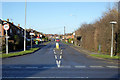
Meadowcroft, Aylesbury
Looking from Weedon Road.
Image: © Robin Webster
Taken: 28 Dec 2017
0.13 miles
4
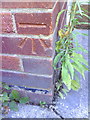
Benchmark on #108 Weedon Road
Ordnance Survey cut mark benchmark described on the Bench Mark Database at http://www.bench-marks.org.uk/bm35812
Image: © Roger Templeman
Taken: 25 Oct 2010
0.16 miles
5
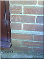
Benchmark on #33 Weedon Road
Ordnance Survey cut mark benchmark described on the Bench Mark Database at http://www.bench-marks.org.uk/bm35811
Image: © Roger Templeman
Taken: 25 Oct 2010
0.17 miles
6

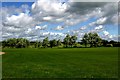
Dog walking paths on the Thame floodplain
Image: © Philip Jeffrey
Taken: 2 Sep 2012
0.18 miles
8
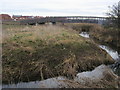
Bridge over the River Thame
Below the new housing development at Weedon Hill a bridge over the River Thame. At present this bridge is fenced off on the Southern end presumably waiting the completion of the housing development
Image: © Shaun Ferguson
Taken: 11 Mar 2009
0.18 miles
9
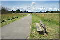
Bench on the Battlefield
An area of grassy meadowland beside the River Thame. An amenity area for most of the time, this is flood plain and is designed to contain flood water should it be necessary.
On 1st November 1642 during the English civil war, the Battle of Aylesbury was fought here around the river crossing at Holman's Bridge. An outnumbered Parliamentary force overcame Prince Rupert's cavalry.
History on http://www.aylesburytowncouncil.gov.uk/wp-content/uploads/2015/11/Civil-War-Battle-.pdf
Image: © Des Blenkinsopp
Taken: 5 Jul 2021
0.19 miles
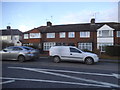
10
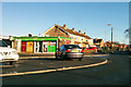
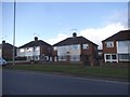
Corner shop, Aylesbury
A Londis newsagents/off-licence/groceries store at the corner of Coventon Road and St Peter's Drive.
Image: © Robin Webster
Taken: 28 Dec 2017
0.19 miles