IMAGES TAKEN NEAR TO
Chantry Road, AYLESBURY, HP19 9NG
Introduction
This page details the photographs taken nearby to Chantry Road, HP19 9NG by members of the Geograph project.
The Geograph project started in 2005 with the aim of publishing, organising and preserving representative images for every square kilometre of Great Britain, Ireland and the Isle of Man.

There are currently over 7.5m images from over14,400 individuals and you can help contribute to the project by visiting https://www.geograph.org.uk
Image Map
Images are licensed for reuse under creativecommons.org/licenses/by-sa/2.0
Notes
- Clicking on the map will re-center to the selected point.
- The higher the marker number, the further away the image location is from the centre of the postcode.
Image Listing (8 Images Found)
Images are licensed for reuse under creativecommons.org/licenses/by-sa/2.0
Image
Details
Distance
1
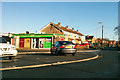
Corner shop, Aylesbury
A Londis newsagents/off-licence/groceries store at the corner of Coventon Road and St Peter's Drive.
Image: © Robin Webster
Taken: 28 Dec 2017
0.06 miles
2
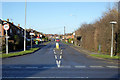
Meadowcroft, Aylesbury
Looking from Weedon Road.
Image: © Robin Webster
Taken: 28 Dec 2017
0.15 miles
3
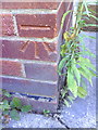
Benchmark on #108 Weedon Road
Ordnance Survey cut mark benchmark described on the Bench Mark Database at http://www.bench-marks.org.uk/bm35812
Image: © Roger Templeman
Taken: 25 Oct 2010
0.20 miles
4
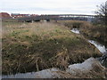
Bridge over the River Thame
Below the new housing development at Weedon Hill a bridge over the River Thame. At present this bridge is fenced off on the Southern end presumably waiting the completion of the housing development
Image: © Shaun Ferguson
Taken: 11 Mar 2009
0.21 miles
5
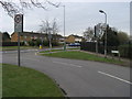
Holman Street
Holman Street joining Weedon Road (A4157)
Image: © Shaun Ferguson
Taken: 11 Mar 2009
0.23 miles
7
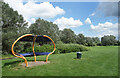
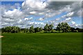
Shelter and Bin in the Park
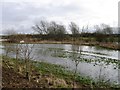
An area of sports field between the river and houses, which continues as grassy parkland beyond the trees at the end. Development keeps well clear of the River Thame through here as it is very prone to flooding.
Image: © Des Blenkinsopp
Taken: 5 Jul 2021
0.24 miles