IMAGES TAKEN NEAR TO
Boarstall, AYLESBURY, HP18 9XX
Introduction
This page details the photographs taken nearby to HP18 9XX by members of the Geograph project.
The Geograph project started in 2005 with the aim of publishing, organising and preserving representative images for every square kilometre of Great Britain, Ireland and the Isle of Man.

There are currently over 7.5m images from over14,400 individuals and you can help contribute to the project by visiting https://www.geograph.org.uk
Image Map
Images are licensed for reuse under creativecommons.org/licenses/by-sa/2.0
Notes
- Clicking on the map will re-center to the selected point.
- The higher the marker number, the further away the image location is from the centre of the postcode.
Image Listing (15 Images Found)
Images are licensed for reuse under creativecommons.org/licenses/by-sa/2.0
Image
Details
Distance
1
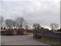
The main entrance to Magnolia Park golf club
Image: © David Howard
Taken: 20 Mar 2016
0.05 miles
2
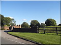
The main entrance to Magnolia Park golf club
Image: © David Howard
Taken: 10 Aug 2017
0.05 miles
4
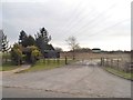
The entrance to Magnolia Park golf and cricket club
Image: © David Howard
Taken: 20 Mar 2016
0.19 miles
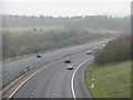
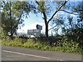
10
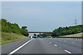
M40 northbound
Between junctions 8a and 9.
Image: © Robin Webster
Taken: 23 Jun 2019
0.23 miles