IMAGES TAKEN NEAR TO
Menmarsh Road, AYLESBURY, HP18 9UW
Introduction
This page details the photographs taken nearby to Menmarsh Road, HP18 9UW by members of the Geograph project.
The Geograph project started in 2005 with the aim of publishing, organising and preserving representative images for every square kilometre of Great Britain, Ireland and the Isle of Man.

There are currently over 7.5m images from over14,400 individuals and you can help contribute to the project by visiting https://www.geograph.org.uk
Image Map
Images are licensed for reuse under creativecommons.org/licenses/by-sa/2.0
Notes
- Clicking on the map will re-center to the selected point.
- The higher the marker number, the further away the image location is from the centre of the postcode.
Image Listing (18 Images Found)
Images are licensed for reuse under creativecommons.org/licenses/by-sa/2.0
Image
Details
Distance
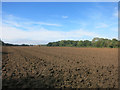
2
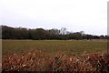
Looking across a field at Joshua Farm
Image: © Steve Daniels
Taken: 13 Feb 2010
0.13 miles
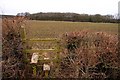
3
Worn out sign at Joshua Farm
This poor old name board at the entrance to Joshua Farm has definitely seen better days.
Image: © Des Blenkinsopp
Taken: 28 Sep 2016
0.13 miles
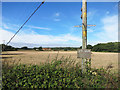
4
Stile on the footpath to Bernwood Forest
Image: © Steve Daniels
Taken: 13 Feb 2010
0.14 miles
5
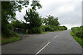
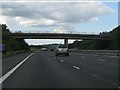
Road over M40 near Worminghall
Taken from west side of bridge over motorway.
Image: © Jackie Harman
Taken: 24 Aug 2006
0.18 miles
6
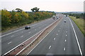
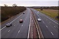
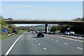
Looking South on M40
Looking South on M40 from the Menmarsh Road Bridge
Image: © Shaun Ferguson
Taken: 7 Oct 2007
0.22 miles