IMAGES TAKEN NEAR TO
Honeyburge, AYLESBURY, HP18 9UT
Introduction
This page details the photographs taken nearby to Honeyburge, HP18 9UT by members of the Geograph project.
The Geograph project started in 2005 with the aim of publishing, organising and preserving representative images for every square kilometre of Great Britain, Ireland and the Isle of Man.

There are currently over 7.5m images from over14,400 individuals and you can help contribute to the project by visiting https://www.geograph.org.uk
Image Map (Loading...)


Getting Data...Please wait
Leaflet Map data © OpenStreetMap
Images are licensed for reuse under creativecommons.org/licenses/by-sa/2.0
Notes
- Clicking on the map will re-center to the selected point.
- The higher the marker number, the further away the image location is from the centre of the postcode.
Image Listing (24 Images Found)
Images are licensed for reuse under creativecommons.org/licenses/by-sa/2.0
Image
Details
Distance
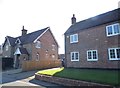
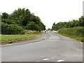
2
Path at Honeyburge
The Bernwood Jubilee way at Honeyburge heading past Boarstall woods
Image: © Shaun Ferguson
Taken: 24 May 2007
0.14 miles
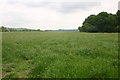
5
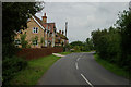
Honeyburge
A hamlet near Boarstall, Bucks.
Image: © Jackie Harman
Taken: 24 Aug 2006
0.18 miles
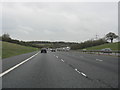
7
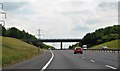
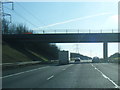
The road runs over the M40 towards Oxford
Image: © Steve Daniels
Taken: 21 Jul 2013
0.19 miles
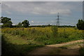
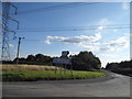
9
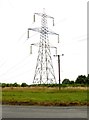
An electricity pylon in a field
The pylon is next to the M40, which is in a cutting.
Image: © Steve Daniels
Taken: 21 Jul 2013
0.20 miles