IMAGES TAKEN NEAR TO
Wotton Road, AYLESBURY, HP18 9UD
Introduction
This page details the photographs taken nearby to Wotton Road, HP18 9UD by members of the Geograph project.
The Geograph project started in 2005 with the aim of publishing, organising and preserving representative images for every square kilometre of Great Britain, Ireland and the Isle of Man.

There are currently over 7.5m images from over14,400 individuals and you can help contribute to the project by visiting https://www.geograph.org.uk
Image Map
Images are licensed for reuse under creativecommons.org/licenses/by-sa/2.0
Notes
- Clicking on the map will re-center to the selected point.
- The higher the marker number, the further away the image location is from the centre of the postcode.
Image Listing (6 Images Found)
Images are licensed for reuse under creativecommons.org/licenses/by-sa/2.0
Image
Details
Distance
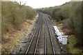
2
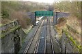
Railway Bridge
This view from the road bridge over the mainline railway that operates today, shows the remnants of a second bridge that would have crossed in parallel. This bridge served the Brill Tramway, which latterly became the strangest stretch of line ever to be considered part of the London Underground when the Metropolitan Line ran it for a good few years in the early part of the 20th century. The bridge it quite wide because it would have carried not only the railway line but also a siding and Wood Siding station.
Image: © Hywel Williams
Taken: 25 Mar 2005
0.13 miles
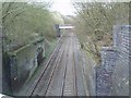
3
Bridge over the Chiltern Line railway
Image: © Steve Daniels
Taken: 14 Jan 2015
0.16 miles
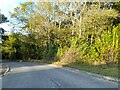
6
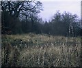
Site of Wood Siding Station, Bucks
Situated on the road between Brill and Wotton Underwood, this station was on the Metropolitan & Great Central Joint Railway line between Brill and Quainton Road. It closed on the 2nd December 1935, and there is now no trace of the station site or the track itself, having been lifted shortly after closure. The Chiltern Railways line from London Marylebone to Birmingham went underneath the station site and the brick remains of the bridge it passed under, can just be seen in the photograph.
Image: © David Hillas
Taken: 27 Dec 1974
0.20 miles