IMAGES TAKEN NEAR TO
Kingswood Lane, AYLESBURY, HP18 9RB
Introduction
This page details the photographs taken nearby to Kingswood Lane, HP18 9RB by members of the Geograph project.
The Geograph project started in 2005 with the aim of publishing, organising and preserving representative images for every square kilometre of Great Britain, Ireland and the Isle of Man.

There are currently over 7.5m images from over14,400 individuals and you can help contribute to the project by visiting https://www.geograph.org.uk
Image Map (Loading...)


Getting Data...Please wait
Leaflet Map data © OpenStreetMap
Images are licensed for reuse under creativecommons.org/licenses/by-sa/2.0
Notes
- Clicking on the map will re-center to the selected point.
- The higher the marker number, the further away the image location is from the centre of the postcode.
Image Listing (8 Images Found)
Images are licensed for reuse under creativecommons.org/licenses/by-sa/2.0
Image
Details
Distance
1
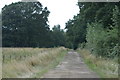
Road to Lapland Farm, Wotton Underwood
Image: © Jackie Harman
Taken: 13 Aug 2006
0.12 miles
2
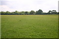
Meadows near Rushbeds wood
Bernwood Way cuts across the meadows near Rushbeds wood
Image: © Shaun Ferguson
Taken: 24 May 2007
0.16 miles
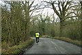
3
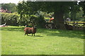
Bernwood Way near Poletrees Farm
Bernwood Way with grazing sheep and horses near Poletrees Farm
Image: © Shaun Ferguson
Taken: 24 May 2007
0.19 miles
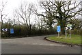
5
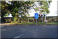
Road junction north of Grenville's Wood
Left for Ludgershall, a route the blue signs apply to, and right for Kingswood on the A41.
Image: © Robin Webster
Taken: 20 Oct 2018
0.23 miles
6
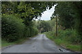
Road alongside Long Wood, Wotton Underwood
Image: © Jackie Harman
Taken: 13 Aug 2006
0.23 miles
8
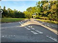
Junction on Kingswood Lane, Wotton Underwood
Image: © David Howard
Taken: 10 Oct 2021
0.24 miles